|
|
Advertisements:
TransportationAirports World Ranking: 90
52 (2012)
Airports - with paved runways
Total 23
Over 3,047 m 4 2,438 to 3,047 m 4 1,524 to 2,437 m 10 914 to 1,523 m 2 Under 914 m 3 (2012) Airports - with unpaved runways
Total 29
2,438 to 3,047 m 5 1,524 to 2,437 m 12 914 to 1,523 m 6 Under 914 m 6 (2012) Heliports
10 (2012)
Pipelines
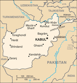
Gas 466 km (2010)
Roadways World Ranking: 86
Total 42,150 km
Paved 12,350 km Unpaved 29,800 km (2006) Waterways World Ranking: 60
1,200 km; (chiefly Amu Darya, which handles vessels up to 500 DWT) (2011) Ports and terminals
Kheyrabad, Shir Khan
Comments
Add a new comment: |
Advertisement
Members area
Afghanistan (Kabul):
 
GPS points from Afghanistan (Kabul)
|
||||||||

 Ahmad Shah DURRANI unified the Pashtun tribes and founded Afghanistan in 1747. The country served as a buffer between the British and Russian Empires until it won independence from notional British control in 1919. A brief experiment in democracy ended in a 1973 coup and a 1978 Communist counter-coup. The Soviet Union invaded in 1979 to support the tottering Afghan Communist regime, touching off a long and destructive war. The USSR withdrew in 1989 under relentless pressure by internationally supported anti-Communist mujahedin rebels. A series of subsequent civil wars saw Kabul finally fall in 1996 to the Taliban, a hardline Pakistani-sponsored movement that emerged in 1994 to end the country's civil war and anarchy. Following the 11 September 2001 terrorist attacks in New York City and Washington, D.C., a US, Allied, and anti-Taliban Northern Alliance military action toppled the Taliban for sheltering Osama BIN LADIN. The UN-sponsored Bonn Conference in 2001 established a process for political reconstruction that included the adoption of a new constitution, a presidential election in 2004, and National Assembly elections in 2005. In December 2004, Hamid KARZAI became the first democratically elected president of Afghanistan and the National Assembly was inaugurated the following December. KARZAI was re-elected in August 2009 for a second term. Despite gains toward building a stable central government, a resurgent Taliban and continuing provincial instability - particularly in the south and the east - remain serious challenges for the Afghan Government. In January 2011, Afghanistan assumed a nonpermanent seat on the UN Security Council for the 2012-13 term.