|
|
|
Advertisements:
GeographyLocation
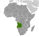
Southern Africa, bordering the South Atlantic Ocean, between Namibia and Democratic Republic of the Congo Geographic coordinates
12 30 S, 18 30 E
Map references
Africa
Area World Ranking: 23
Total 1,246,700 sq km
Land 1,246,700 sq km Water 0 sq km Area - comparative
Slightly less than twice the size of Texas Land boundaries
Total 5,198 km
Border countries Democratic Republic of the Congo 2,511 km (of which 225 km is the boundary of discontiguous Cabinda Province), Republic of the Congo 201 km, Namibia 1,376 km, Zambia 1,110 km Coastline
1,600 km
Maritime claims
Territorial sea 12 nm
Contiguous zone 24 nm Exclusive economic zone 200 nm Climate
Semiarid in south and along coast to Luanda; north has cool, dry season (May to October) and hot, rainy season (November to April) Terrain
Narrow coastal plain rises abruptly to vast interior plateau Elevation extremes
Lowest point Atlantic Ocean 0 m
Highest point Morro de Moco 2,620 m Natural resources
Petroleum, diamonds, iron ore, phosphates, copper, feldspar, gold, bauxite, uranium Land use
Arable land 2.65%
Permanent crops 0.23% Other 97.12% (2005) Irrigated land
800 sq km (2003)
Total renewable water resources
184 cu km (1987)
Freshwater withdrawal (domestic/industrial/agricultural)
Total 0.35 cu km/yr (23%/17%/60%)
Per capita 22 cu m/yr (2000) Natural hazards
Locally heavy rainfall causes periodic flooding on the plateau Environment - current issues
Overuse of pastures and subsequent soil erosion attributable to population pressures; desertification; deforestation of tropical rain forest, in response to both international demand for tropical timber and to domestic use as fuel, resulting in loss of biodiversity; soil erosion contributing to water pollution and siltation of rivers and dams; inadequate supplies of potable water Environment - international agreements
Party to
Biodiversity, Climate Change, Climate Change-Kyoto Protocol, Desertification, Law of the Sea, Marine Dumping, Ozone Layer Protection, Ship Pollution Signed, but not ratified None of the selected agreements Geography - note
The province of Cabinda is an exclave, separated from the rest of the country by the Democratic Republic of the Congo
Comments
Add a new comment: |
Advertisement
Members area
Angola (Luanda):
 
GPS points from Angola (Luanda)
|
||||||||

 Angola is rebuilding its country after the end of a 27-year civil war in 2002. Fighting between the Popular Movement for the Liberation of Angola (MPLA), led by Jose Eduardo DOS SANTOS, and the National Union for the Total Independence of Angola (UNITA), led by Jonas SAVIMBI, followed independence from Portugal in 1975. Peace seemed imminent in 1992 when Angola held national elections, but fighting picked up again by 1996. Up to 1.5 million lives may have been lost - and 4 million people displaced - in the quarter century of fighting. SAVIMBI's death in 2002 ended UNITA's insurgency and strengthened the MPLA's hold on power. President DOS SANTOS held legislative elections in September 2008 and, despite promising to hold presidential elections in 2009, has since pushed through a new constitution that calls for elections in 2012.