|
|
|
Advertisements:
GeographyLocation
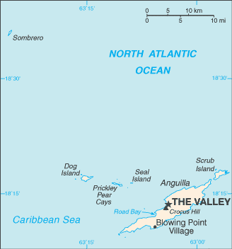
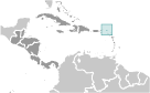
Caribbean, islands between the Caribbean Sea and North Atlantic Ocean, east of Puerto Rico Geographic coordinates
18 15 N, 63 10 W
Map references
Central America and the Caribbean
Area World Ranking: 226
Total 91 sq km
Land 91 sq km Water 0 sq km Area - comparative
About one-half the size of Washington, DC Land boundaries
0 km
Coastline
61 km
Maritime claims
Territorial sea 3 nm
Exclusive fishing zone 200 nm Climate
Tropical; moderated by northeast trade winds Terrain
Flat and low-lying island of coral and limestone Elevation extremes
Lowest point Caribbean Sea 0 m
Highest point Crocus Hill 65 m Natural resources
Salt, fish, lobster
Land use
Arable land 0%
Permanent crops 0% Other 100% (mostly rock with sparse scrub oak, few trees, some commercial salt ponds) (2005) Irrigated land
NA
Natural hazards
Frequent hurricanes and other tropical storms (July to October) Environment - current issues
Supplies of potable water sometimes cannot meet increasing demand largely because of poor distribution system Geography - note
The most northerly of the Leeward Islands in the Lesser Antilles
Comments
Add a new comment: |
Advertisement
Members area
Anguilla [ United Kingdom ] (Overseas Territory):
GPS points from Anguilla [ United Kingdom ] (Overseas Territory)
|
||||||||
 Colonized by English settlers from Saint Kitts in 1650, Anguilla was administered by Great Britain until the early 19th century, when the island - against the wishes of the inhabitants - was incorporated into a single British dependency along with Saint Kitts and Nevis. Several attempts at separation failed. In 1971, two years after a revolt, Anguilla was finally allowed to secede; this arrangement was formally recognized in 1980 with Anguilla becoming a separate British dependency.