|
|
|
Advertisements:
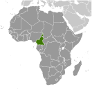
GeographyLocation
Central Africa, bordering the Bight of Biafra, between Equatorial Guinea and Nigeria Geographic coordinates
6 00 N, 12 00 E
Map references
Africa
Area World Ranking: 54
Total 475,440 sq km
Land 472,710 sq km Water 2,730 sq km Area - comparative
Slightly larger than California Land boundaries
Total 4,591 km
Border countries Central African Republic 797 km, Chad 1,094 km, Republic of the Congo 523 km, Equatorial Guinea 189 km, Gabon 298 km, Nigeria 1,690 km Coastline
402 km
Maritime claims
Territorial sea 12 nm
Contiguous zone 24 nm Climate
Varies with terrain, from tropical along coast to semiarid and hot in north Terrain
Diverse, with coastal plain in southwest, dissected plateau in center, mountains in west, plains in north Elevation extremes
Lowest point Atlantic Ocean 0 m
Highest point Fako 4,095 m (on Mt. Cameroon) Natural resources
Petroleum, bauxite, iron ore, timber, hydropower Land use
Arable land 12.6%
Permanent crops 2.52% Other 84.86% (2005) Irrigated land
290 sq km (2003)
Total renewable water resources
273 cu km (2003)
Freshwater withdrawal (domestic/industrial/agricultural)
Total
1.18 cu km/yr (18.2%/8.1%/73.7%) Per capita 601 cu m/yr (2000)Natural hazards
Volcanic activity with periodic releases of poisonous gases from Lake Nyos and Lake Monoun volcanoes Volcanism Mt. Cameroon (elev. 4,095 m), which last erupted in 2000, is the most frequently active volcano in West Africa; lakes in Oku volcanic field have released fatal levels of gas on occasion, killing some 1,700 people in 1986 Environment - current issues
Waterborne diseases are prevalent; deforestation; overgrazing; desertification; poaching; overfishing Environment - international agreements
Party to
Biodiversity, Climate Change, Climate Change-Kyoto Protocol, Desertification, Endangered Species, Hazardous Wastes, Law of the Sea, Ozone Layer Protection, Tropical Timber 83, Tropical Timber 94, Wetlands, Whaling Signed, but not ratified None of the selected agreements Geography - note
Sometimes referred to as the hinge of Africa; throughout the country there are areas of thermal springs and indications of current or prior volcanic activity; Mount Cameroon, the highest mountain in Sub-Saharan west Africa, is an active volcano
Comments
Add a new comment: |
Advertisement
Members area
Cameroon (Yaounde):
 
GPS points from Cameroon (Yaounde)
|
||||||||

 French Cameroon became independent in 1960 as the Republic of Cameroon. The following year the southern portion of neighboring British Cameroon voted to merge with the new country to form the Federal Republic of Cameroon. In 1972, a new constitution replaced the federation with a unitary state, the United Republic of Cameroon. The country has generally enjoyed stability, which has permitted the development of agriculture, roads, and railways, as well as a petroleum industry. Despite slow movement toward democratic reform, political power remains firmly in the hands of President Paul BIYA.