|
|
|
Advertisements:
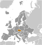
GeographyLocation
Central Europe, between Germany, Poland, Slovakia, and Austria Geographic coordinates
49 45 N, 15 30 E
Map references
Europe
Area World Ranking: 116
Total 78,867 sq km
Land 77,247 sq km Water 1,620 sq km Area - comparative
Slightly smaller than South Carolina Land boundaries
Total 1,989 km
Border countries Austria 362 km, Germany 815 km, Poland 615 km, Slovakia 197 km Coastline
0 km (landlocked)
Maritime claims
None (landlocked)
Climate
Temperate; cool summers; cold, cloudy, humid winters Terrain
Bohemia in the west consists of rolling plains, hills, and plateaus surrounded by low mountains; Moravia in the east consists of very hilly country Elevation extremes
Lowest point Elbe River 115 m
Highest point Snezka 1,602 m Natural resources
Hard coal, soft coal, kaolin, clay, graphite, timber Land use
Arable land 38.82%
Permanent crops 3% Other 58.18% (2005) Irrigated land
390 sq km (2003)
Total renewable water resources
16 cu km (2005)
Freshwater withdrawal (domestic/industrial/agricultural)
Total 1.91 cu km/yr (41%/57%/2%)
Per capita 187 cu m/yr (2002) Natural hazards
Flooding
Environment - current issues
Air and water pollution in areas of northwest Bohemia and in northern Moravia around Ostrava present health risks; acid rain damaging forests; efforts to bring industry up to EU code should improve domestic pollution Environment - international agreements
Party to
Air Pollution, Air Pollution-Nitrogen Oxides, Air Pollution-Persistent Organic Pollutants, Air Pollution-Sulfur 85, Air Pollution-Sulfur 94, Air Pollution-Volatile Organic Compounds, Antarctic-Environmental Protocol, Antarctic Treaty, Biodiversity, Climate Change, Climate Change-Kyoto Protocol, Desertification, Endangered Species, Environmental Modification, Hazardous Wastes, Law of the Sea, Ozone Layer Protection, Ship Pollution, Wetlands, Whaling Signed, but not ratified None of the selected agreements Geography - note
Landlocked; strategically located astride some of oldest and most significant land routes in Europe; Moravian Gate is a traditional military corridor between the North European Plain and the Danube in central Europe
Comments
Add a new comment: |
Advertisement
Members area
Czech Republic (Prague):
 
GPS points from Czech Republic (Prague)
|
||||||||

 At the close of World War I, the Czechs and Slovaks of the former Austro-Hungarian Empire merged to form Czechoslovakia. During the interwar years, having rejected a federal system, the new country's leaders were frequently preoccupied with meeting the demands of other ethnic minorities within the republic, most notably the Sudeten Germans and the Ruthenians (Ukrainians). On the eve of World War II, the Czech part of the country was forcibly annexed to the Third Reich, and the Slovaks declared independence as an ally of Nazi Germany. After the war, a reunited but truncated Czechoslovakia (less Ruthenia) fell within the Soviet sphere of influence. In 1968, an invasion by Warsaw Pact troops ended the efforts of the country's leaders to liberalize Communist Party rule and create "socialism with a human face." Anti-Soviet demonstrations the following year ushered in a period of harsh repression known as "normalization." With the collapse of Soviet-backed authority in 1989, Czechoslovakia regained its democracy through a peaceful "Velvet Revolution." On 1 January 1993, the country underwent a "velvet divorce" into its two national components, the Czech Republic and Slovakia. The Czech Republic joined NATO in 1999 and the European Union in 2004.