|
|
Advertisements:
GeographyLocation
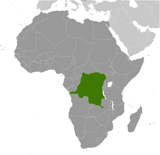
Central Africa, northeast of Angola Geographic coordinates
0 00 N, 25 00 E
Map references
Africa
Area World Ranking: 11
Total 2,344,858 sq km
Land 2,267,048 sq km Water 77,810 sq km Area - comparative
Slightly less than one-fourth the size of the US Land boundaries
Total 10,730 km
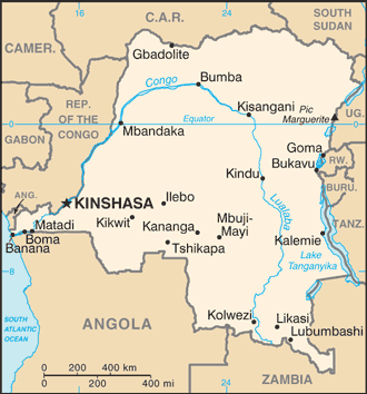
Border countries Angola 2,511 km (of which 225 km is the boundary of Angola's discontiguous Cabinda Province), Burundi 233 km, Central African Republic 1,577 km, Republic of the Congo 2,410 km, Rwanda 217 km, South Sudan 628 km, Tanzania 459 km, Uganda 765 km, Zambia 1,930 km Coastline
37 km
Maritime claims
Territorial sea 12 nm
Exclusive economic zone Boundaries with neighbors Climate
Tropical; hot and humid in equatorial river basin; cooler and drier in southern highlands; cooler and wetter in eastern highlands; north of Equator - wet season (April to October), dry season (December to February); south of Equator - wet season (November to March), dry season (April to October) Terrain
Vast central basin is a low-lying plateau; mountains in east Elevation extremes
Lowest point Atlantic Ocean 0 m
Highest point Pic Marguerite on Mont Ngaliema (Mount Stanley) 5,110 m Natural resources
Cobalt, copper, niobium, tantalum, petroleum, industrial and gem diamonds, gold, silver, zinc, manganese, tin, uranium, coal, hydropower, timber Land use
Arable land 2.86%
Permanent crops 0.47% Other 96.67% (2005) Irrigated land
110 sq km (2003)
Total renewable water resources
1,283 cu km (2001)
Freshwater withdrawal (domestic/industrial/agricultural)
Total 0.36 cu km/yr (53%/17%/31%)
Per capita 6 cu m/yr (2000) Natural hazards
Periodic droughts in south; Congo River floods (seasonal); active volcanoes in the east along the Great Rift Valley Volcanism Nyiragongo (elev. 3,470 m), which erupted in 2002 and is experiencing ongoing activity, poses a major threat to the city of Goma, home to a quarter million people; the volcano produces unusually fast-moving lava, known to travel up to 100 km /hr; Nyiragongo has been deemed a "Decade Volcano" by the International Association of Volcanology and Chemistry of the Earth's Interior, worthy of study due to its explosive history and close proximity to human populations; its neighbor, Nyamuragira, which erupted in 2010, is Africa's most active volcano; Visoke is the only other historically active volcano Environment - current issues
Poaching threatens wildlife populations; water pollution; deforestation; refugees responsible for significant deforestation, soil erosion, and wildlife poaching; mining of minerals (coltan - a mineral used in creating capacitors, diamonds, and gold) causing environmental damage Environment - international agreements
Party to
Biodiversity, Climate Change, Climate Change-Kyoto Protocol, Desertification, Endangered Species, Hazardous Wastes, Law of the Sea, Marine Dumping, Ozone Layer Protection, Tropical Timber 83, Tropical Timber 94, Wetlands Signed, but not ratified Environmental ModificationGeography - note
Straddles equator; has narrow strip of land that controls the lower Congo River and is only outlet to South Atlantic Ocean; dense tropical rain forest in central river basin and eastern highlands; second largest country in Africa (after Algeria)
Comments
Add a new comment: |
Advertisement
Members area
Democratic Republic Of The Congo (Kinshasa):
 
GPS points from Democratic Republic Of The Congo (Kinshasa)
|
||||||||

 Established as a Belgian colony in 1908, the then-Republic of the Congo gained its independence in 1960, but its early years were marred by political and social instability. Col. Joseph MOBUTU seized power and declared himself president in a November 1965 coup. He subsequently changed his name - to MOBUTU Sese Seko - as well as that of the country - to Zaire. MOBUTU retained his position for 32 years through several sham elections, as well as through brutal force. Ethnic strife and civil war, touched off by a massive inflow of refugees in 1994 from fighting in Rwanda and Burundi, led in May 1997 to the toppling of the MOBUTU regime by a rebellion backed by Rwanda and Uganda and fronted by Laurent KABILA. He renamed the country the Democratic Republic of the Congo (DRC), but in August 1998 his regime was itself challenged by a second insurrection again backed by Rwanda and Uganda. Troops from Angola, Chad, Namibia, Sudan, and Zimbabwe intervened to support KABILA's regime. A cease-fire was signed in July 1999 by the DRC, Congolese armed rebel groups, Angola, Namibia, Rwanda, Uganda, and Zimbabwe but sporadic fighting continued. Laurent KABILA was assassinated in January 2001 and his son, Joseph KABILA, was named head of state. In October 2002, the new president was successful in negotiating the withdrawal of Rwandan forces occupying eastern Congo; two months later, the Pretoria Accord was signed by all remaining warring parties to end the fighting and establish a government of national unity. A transitional government was set up in July 2003; it held a successful constitutional referendum in December 2005 and elections for the presidency, National Assembly, and provincial legislatures took place in 2006. In the most recent national elections, held in November 2011, disputed results allowed Joseph KABILA to be reelected to the presidency .