|
|
|
Advertisements:
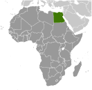
GeographyLocation
Northern Africa, bordering the Mediterranean Sea, between Libya and the Gaza Strip, and the Red Sea north of Sudan, and includes the Asian Sinai Peninsula Geographic coordinates
27 00 N, 30 00 E
Map references
Africa
Area World Ranking: 30
Total 1,001,450 sq km
Land 995,450 sq km Water 6,000 sq km Area - comparative
Slightly more than three times the size of New Mexico Land boundaries
Total 2,665 km
Border countries Gaza Strip 11 km, Israel 266 km, Libya 1,115 km, Sudan 1,273 km Coastline
2,450 km
Maritime claims
Territorial sea 12 nm
Contiguous zone 24 nm Exclusive economic zone 200 nm Continental shelf 200 m depth or to the depth of exploitation Climate
Desert; hot, dry summers with moderate winters Terrain
Vast desert plateau interrupted by Nile valley and delta Elevation extremes
Lowest point Qattara Depression -133 m
Highest point Mount Catherine 2,629 m Natural resources
Petroleum, natural gas, iron ore, phosphates, manganese, limestone, gypsum, talc, asbestos, lead, rare earth elements, zinc Land use
Arable land 2.92%
Permanent crops 0.5% Other 96.58% (2005) Irrigated land
35,300 sq km (2003)
Total renewable water resources
86.8 cu km (1997)
Freshwater withdrawal (domestic/industrial/agricultural)
Total 68.3 cu km/yr (8%/6%/86%)
Per capita 923 cu m/yr (2000) Natural hazards
Periodic droughts; frequent earthquakes; flash floods; landslides; hot, driving windstorms called khamsin occur in spring; dust storms; sandstorms Environment - current issues
Agricultural land being lost to urbanization and windblown sands; increasing soil salination below Aswan High Dam; desertification; oil pollution threatening coral reefs, beaches, and marine habitats; other water pollution from agricultural pesticides, raw sewage, and industrial effluents; limited natural freshwater resources away from the Nile, which is the only perennial water source; rapid growth in population overstraining the Nile and natural resources Environment - international agreements
Party to
Biodiversity, Climate Change, Climate Change-Kyoto Protocol, Desertification, Endangered Species, Environmental Modification, Hazardous Wastes, Law of the Sea, Marine Dumping, Ozone Layer Protection, Ship Pollution, Tropical Timber 83, Tropical Timber 94, Wetlands Signed, but not ratified None of the selected agreements Geography - note
Controls Sinai Peninsula, only land bridge between Africa and remainder of Eastern Hemisphere; controls Suez Canal, a sea link between Indian Ocean and Mediterranean Sea; size, and juxtaposition to Israel, establish its major role in Middle Eastern geopolitics; dependence on upstream neighbors; dominance of Nile basin issues; prone to influxes of refugees from Sudan and the Palestinian territories
Comments
Add a new comment: |
Advertisement
Members area
Egypt (Cairo):
 
GPS points from Egypt (Cairo)
|
||||||||

 The regularity and richness of the annual Nile River flood, coupled with semi-isolation provided by deserts to the east and west, allowed for the development of one of the world's great civilizations. A unified kingdom arose circa 3200 B.C., and a series of dynasties ruled in Egypt for the next three millennia. The last native dynasty fell to the Persians in 341 B.C., who in turn were replaced by the Greeks, Romans, and Byzantines. It was the Arabs who introduced Islam and the Arabic language in the 7th century and who ruled for the next six centuries. A local military caste, the Mamluks took control about 1250 and continued to govern after the conquest of Egypt by the Ottoman Turks in 1517. Following the completion of the Suez Canal in 1869, Egypt became an important world transportation hub, but also fell heavily into debt. Ostensibly to protect its investments, Britain seized control of Egypt's government in 1882, but nominal allegiance to the Ottoman Empire continued until 1914. Partially independent from the UK in 1922, Egypt acquired full sovereignty with the overthrow of the British-backed monarchy in 1952. The completion of the Aswan High Dam in 1971 and the resultant Lake Nasser have altered the time-honored place of the Nile River in the agriculture and ecology of Egypt. A rapidly growing population (the largest in the Arab world), limited arable land, and dependence on the Nile all continue to overtax resources and stress society. The government has struggled to meet the demands of Egypt's growing population through economic reform and massive investment in communications and physical infrastructure. Egyptian youth and opposition groups, inspired by events in Tunisia leading to overthrow of the government there, organized a "Day of Rage" campaign on 25 January 2011 (Police Day) to include non-violent demonstrations, marches, and labor strikes in Cairo and other cities throughout Egypt. Protester grievances focused on police brutality, state emergency laws, lack of free speech and elections, high unemployment, rising food prices, inflation, and low minimum wages. Within several days of the onset of protests, President MUBARAK addressed the nation pledging the formation of a new government, and in a second address he offered additional concessions, which failed to assuage protesters and resulted in an escalation of the number and intensity of demonstrations and clashes with police. On 11 February MUBARAK resigned and national leadership was assumed by a Supreme Council of Armed Forces (SCAF). The SCAF dissolved the Egyptian parliament, suspended the nation's constitution, and formed a committee to recommend constitutional changes to facilitate a political transition through democratic elections. Following some delays, elections for a new parliament took place between November 2011 and January 2012. Presidential elections held in May and June witnessed the victory of Muslim Brotherhood candidate Mohammed MURSI over former Prime Minister Ahmed SHAFIQ.