|
|
Advertisements:
GeographyLocation
Metropolitan France
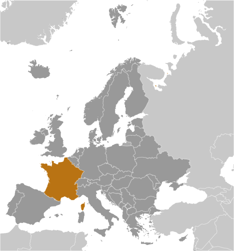
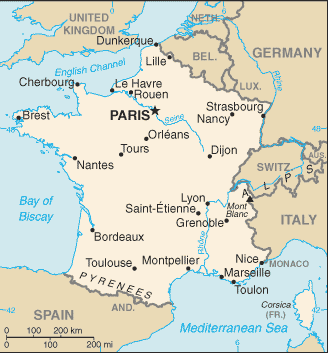
Western Europe, bordering the Bay of Biscay and English Channel, between Belgium and Spain, southeast of the UK; bordering the Mediterranean Sea, between Italy and Spain French Guiana Northern South America, bordering the North Atlantic Ocean, between Brazil and Suriname Guadeloupe Caribbean, islands between the Caribbean Sea and the North Atlantic Ocean, southeast of Puerto Rico Martinique Caribbean, island between the Caribbean Sea and North Atlantic Ocean, north of Trinidad and Tobago Mayotte Southern Indian Ocean, island in the Mozambique Channel, about half way between northern Madagascar and northern Mozambique Reunion Southern Africa, island in the Indian Ocean, east of Madagascar Geographic coordinates
Metropolitan France 46 00 N, 2 00 E
French Guiana 4 00 N, 53 00 W Guadeloupe 16 15 N, 61 35 W Martinique 14 40 N, 61 00 W Mayotte 12 50 S, 45 10 E Reunion 21 06 S, 55 36 E Map references
Metropolitan France Europe
French Guiana South America Guadeloupe Central America and the Caribbean Martinique Central America and the Caribbean Mayotte AfricaReunion World Area World Ranking: 43
Total
643,801 sq km; 551,500 sq km (metropolitan France) Land 640,427 sq km; 549,970 sq km (metropolitan France) Water 3,374 sq km; 1,530 sq km (metropolitan France) Note The first numbers include the overseas regions of French Guiana, Guadeloupe, Martinique, Mayotte, and Reunion Area - comparative
Slightly less than the size of Texas Land boundaries
Metropolitan France - total 2,889 km
Border countries Andorra 56.6 km, Belgium 620 km, Germany 451 km, Italy 488 km, Luxembourg 73 km, Monaco 4.4 km, Spain 623 km, Switzerland 573 km French Guiana - total 1,183 kmBorder countries Brazil 673 km, Suriname 510 km Coastline
Total 4,853 km
Metropolitan France 3,427 km Maritime claims
Territorial sea 12 nm
Contiguous zone 24 nm Exclusive economic zone 200 nm (does not apply to the Mediterranean) Continental shelf 200 m depth or to the depth of exploitation Climate
Metropolitan France
Generally cool winters and mild summers, but mild winters and hot summers along the Mediterranean; occasional strong, cold, dry, north-to-northwesterly wind known as mistral French Guiana Tropical; hot, humid; little seasonal temperature variation Guadeloupe and Martinique Subtropical tempered by trade winds; moderately high humidity; rainy season (June to October); vulnerable to devastating cyclones (hurricanes) every eight years on average Mayotte Tropical; marine; hot, humid, rainy season during northeastern monsoon (November to May); dry season is cooler (May to November) Reunion Tropical, but temperature moderates with elevation; cool and dry (May to November), hot and rainy (November to April) Terrain
Metropolitan France
Mostly flat plains or gently rolling hills in north and west; remainder is mountainous, especially Pyrenees in south, Alps in east French Guiana Low-lying coastal plains rising to hills and small mountains Guadeloupe Basse-Terre is volcanic in origin with interior mountains; Grande-Terre is low limestone formation; most of the seven other islands are volcanic in origin Martinique Mountainous with indented coastline; dormant volcano Mayotte Generally undulating, with deep ravines and ancient volcanic peaks Reunion Mostly rugged and mountainous; fertile lowlands along coast Elevation extremes
Lowest point Rhone River delta -2 m
Highest point Mont Blanc 4,807 m Note In order to assess the possible effects of climate change on the ice and snow cap of Mont Blanc, its surface and peak have been extensively measured in recent years; these new peak measurements have exceeded the traditional height of 4,807 m and have varied between 4,808 m and 4,811 m; the actual rock summit is 4,792 m and is 40 m away from the ice-covered summit Natural resources
Metropolitan France
Coal, iron ore, bauxite, zinc, uranium, antimony, arsenic, potash, feldspar, fluorspar, gypsum, timber, fish French Guiana Gold deposits, petroleum, kaolin, niobium, tantalum, clay Land use
Arable land 33.46%
Permanent crops 2.03% Other 64.51% Note French Guiana - arable land 0.13%, permanent crops 0.04%, other 99.83% (90% forest, 10% other); Guadeloupe - arable land 11.70%, permanent crops 2.92%, other 85.38%; Martinique - arable land 9.09%, permanent crops 10.0%, other 80.91%; Reunion - arable land 13.94%, permanent crops 1.59%, other 84.47% (2005) Irrigated land
Total 26,950 sq km;
Metropolitan France 26,700 sq km (2003) Total renewable water resources
189 cu km (2005)
Freshwater withdrawal (domestic/industrial/agricultural)
Total 33.16 cu km/yr (16%/74%/10%)
Per capita 548 cu m/yr (2000) Natural hazards
Metropolitan France
Flooding; avalanches; midwinter windstorms; drought; forest fires in south near the Mediterranean Overseas departments Hurricanes (cyclones); flooding; volcanic activity (Guadeloupe, Martinique, Reunion) Environment - current issues
Some forest damage from acid rain; air pollution from industrial and vehicle emissions; water pollution from urban wastes, agricultural runoff Environment - international agreements
Party to
Air Pollution, Air Pollution-Nitrogen Oxides, Air Pollution-Persistent Organic Pollutants, Air Pollution-Sulfur 85, Air Pollution-Sulfur 94, Air Pollution-Volatile Organic Compounds, Antarctic-Environmental Protocol, Antarctic-Marine Living Resources, Antarctic Seals, Antarctic Treaty, Biodiversity, Climate Change, Climate Change-Kyoto Protocol, Desertification, Endangered Species, Hazardous Wastes, Law of the Sea, Marine Dumping, Marine Life Conservation, Ozone Layer Protection, Ship Pollution, Tropical Timber 83, Tropical Timber 94, Wetlands, Whaling Signed, but not ratified None of the selected agreements Geography - note
Largest West European nation
Comments
Add a new comment: |
Advertisement
Members area
France (Paris):
 
GPS points from France (Paris)
|
||||||||

 France today is one of the most modern countries in the world and is a leader among European nations. It plays an influential global role as a permanent member of the United Nations Security Council, NATO, the G-8, the G-20, the EU and other multilateral organizations. France rejoined NATO's integrated military command structure in 2009, reversing de Gaulle's 1966 decision to take French forces out of NATO. Since 1958, it has constructed a hybrid presidential-parliamentary governing system resistant to the instabilities experienced in earlier more purely parliamentary administrations. In recent decades, its reconciliation and cooperation with Germany have proved central to the economic integration of Europe, including the introduction of a common exchange currency, the euro, in January 1999. In the early 21st century, five French overseas entities - French Guiana, Guadeloupe, Martinique, Mayotte, and Reunion - became French regions and were made part of France proper.