|
Administrative divisions (GPS Maps)
Geography
People and Society
Government
Economy
Communications
Transportation
Military |
 |
 The September 1993 Israel-PLO Declaration of Principles on Interim Self-Government Arrangements provided for a transitional period of Palestinian self-rule in the West Bank and Gaza Strip. Under a series of agreements signed between May 1994 and September 1999, Israel transferred to the Palestinian Authority (PA) security and civilian responsibility for many Palestinian-populated areas of the West Bank and Gaza Strip. Negotiations to determine the permanent status of the West Bank and Gaza Strip stalled following the outbreak of an intifada in September 2000. In April 2003, the Quartet (US, EU, UN, and Russia) presented a roadmap to a final settlement of the conflict by 2005 based on reciprocal steps by the two parties leading to two states, Israel and a democratic Palestine. Following Palestinian leader Yasir ARAFAT's death in late 2004, Mahmud ABBAS was elected PA president in January 2005. A month later, Israel and the PA agreed to the Sharm el-Sheikh Commitments in an effort to move the peace process forward. In September 2005, Israel unilaterally withdrew all of its settlers and soldiers and dismantled its military facilities in the Gaza Strip and withdrew settlers and redeployed soldiers from four small northern West Bank settlements. Nonetheless, Israel still controls maritime, airspace, and other access to the Gaza Strip; Israel also enforces a restricted zone along the border inside Gaza. In January 2006, the Islamic Resistance Movement, HAMAS, won control of the Palestinian Legislative Council (PLC). HAMAS took control of the PA government in March 2006, but President ABBAS had little success negotiating with HAMAS to present a political platform acceptable to the international community so as to lift economic sanctions on Palestinians. Violent clashes between Fatah and HAMAS supporters in the Gaza Strip in 2006 and early 2007 resulted in numerous Palestinian deaths and injuries. In February 2007, ABBAS and HAMAS Political Bureau Chief Khalid MISHAL signed the Mecca Agreement in Saudi Arabia that resulted in the formation of a Palestinian National Unity Government (NUG) headed by HAMAS member Ismail HANIYA. However, fighting continued in the Gaza Strip, and in June 2007, HAMAS militants succeeded in a violent takeover of all military and governmental institutions in the Gaza Strip. ABBAS that same month dismissed the NUG and through a series of presidential decrees formed a PA government in the West Bank led by independent Salam FAYYAD. Late November 2007 through June 2008 witnessed a substantial increase in Israeli-Palestinian violence. An Egyptian-brokered truce in June 2008 between Israel and HAMAS brought about a five-month pause in hostilities, but spiraling end-of-year violence resulted in the deaths of an estimated 1,100 to 1,400 Palestinians and left tens of thousands of people homeless. International donors pledged $4.5 billion in aid to rebuild the Gaza Strip, but by the end of 2011 large-scale reconstruction had not begun. Fatah and HAMAS in May 2011, under the auspices of Egyptian-sponsored reconciliation negotiations, agreed to reunify the Palestinian territories, but the factions have struggled to finalize details on governing and security structures. The status quo remains with HAMAS in control of the Gaza Strip and ABBAS and the Fatah-dominated PA governing the West Bank. The September 1993 Israel-PLO Declaration of Principles on Interim Self-Government Arrangements provided for a transitional period of Palestinian self-rule in the West Bank and Gaza Strip. Under a series of agreements signed between May 1994 and September 1999, Israel transferred to the Palestinian Authority (PA) security and civilian responsibility for many Palestinian-populated areas of the West Bank and Gaza Strip. Negotiations to determine the permanent status of the West Bank and Gaza Strip stalled following the outbreak of an intifada in September 2000. In April 2003, the Quartet (US, EU, UN, and Russia) presented a roadmap to a final settlement of the conflict by 2005 based on reciprocal steps by the two parties leading to two states, Israel and a democratic Palestine. Following Palestinian leader Yasir ARAFAT's death in late 2004, Mahmud ABBAS was elected PA president in January 2005. A month later, Israel and the PA agreed to the Sharm el-Sheikh Commitments in an effort to move the peace process forward. In September 2005, Israel unilaterally withdrew all of its settlers and soldiers and dismantled its military facilities in the Gaza Strip and withdrew settlers and redeployed soldiers from four small northern West Bank settlements. Nonetheless, Israel still controls maritime, airspace, and other access to the Gaza Strip; Israel also enforces a restricted zone along the border inside Gaza. In January 2006, the Islamic Resistance Movement, HAMAS, won control of the Palestinian Legislative Council (PLC). HAMAS took control of the PA government in March 2006, but President ABBAS had little success negotiating with HAMAS to present a political platform acceptable to the international community so as to lift economic sanctions on Palestinians. Violent clashes between Fatah and HAMAS supporters in the Gaza Strip in 2006 and early 2007 resulted in numerous Palestinian deaths and injuries. In February 2007, ABBAS and HAMAS Political Bureau Chief Khalid MISHAL signed the Mecca Agreement in Saudi Arabia that resulted in the formation of a Palestinian National Unity Government (NUG) headed by HAMAS member Ismail HANIYA. However, fighting continued in the Gaza Strip, and in June 2007, HAMAS militants succeeded in a violent takeover of all military and governmental institutions in the Gaza Strip. ABBAS that same month dismissed the NUG and through a series of presidential decrees formed a PA government in the West Bank led by independent Salam FAYYAD. Late November 2007 through June 2008 witnessed a substantial increase in Israeli-Palestinian violence. An Egyptian-brokered truce in June 2008 between Israel and HAMAS brought about a five-month pause in hostilities, but spiraling end-of-year violence resulted in the deaths of an estimated 1,100 to 1,400 Palestinians and left tens of thousands of people homeless. International donors pledged $4.5 billion in aid to rebuild the Gaza Strip, but by the end of 2011 large-scale reconstruction had not begun. Fatah and HAMAS in May 2011, under the auspices of Egyptian-sponsored reconciliation negotiations, agreed to reunify the Palestinian territories, but the factions have struggled to finalize details on governing and security structures. The status quo remains with HAMAS in control of the Gaza Strip and ABBAS and the Fatah-dominated PA governing the West Bank. |
|
Advertisements
|
Advertisements
|
Location
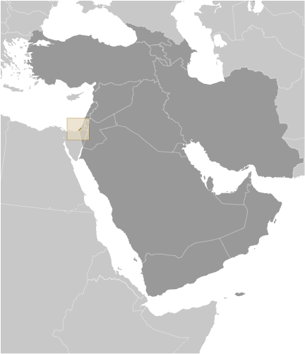
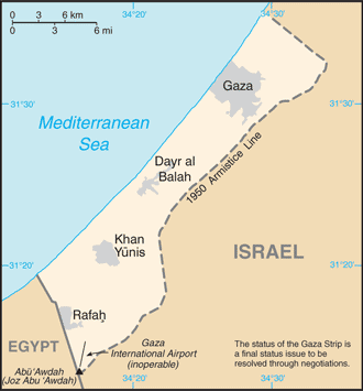
Middle East, bordering the Mediterranean Sea, between Egypt and Israel
Geographic coordinates
31 25 N, 34 20 E
Map references
Area World Ranking: 205
Total 360 sq km
Land 360 sq km
Water 0 sq km
Area - comparative
Slightly more than twice the size of Washington, DC
Land boundaries
Total 62 km
Border countries Egypt 11 km, Israel 51 km
Coastline
40 km
Maritime claims
See entry for Israel Note Effective 3 January 2009 the Gaza maritime area is closed to all maritime traffic and is under blockade imposed by Israeli Navy until further notice
Climate
Temperate, mild winters, dry and warm to hot summers
Terrain
Flat to rolling, sand- and dune-covered coastal plain
Elevation extremes
Lowest point Mediterranean Sea 0 m Highest point Abu 'Awdah (Joz Abu 'Awdah) 105 m
Natural resources
Arable land, natural gas
Land use
Arable land 29%
Permanent crops 21%
Other 50% (2002)
Irrigated land
180 sq km; note - includes West Bank (2003)
Natural hazards
Droughts
Environment - current issues
Desertification; salination of fresh water; sewage treatment; water-borne disease; soil degradation; depletion and contamination of underground water resources
Geography - note
Strategic strip of land along Mideast-North African trade routes has experienced an incredibly turbulent history; the town of Gaza itself has been besieged countless times in its history
--- There are no comments yet ---
Add a new comment:
|
Advertisement
Members area
Gaza Strip:
GPS points from Gaza Strip
 Dugit Gaza Strip (general)
|