|
|
|
Advertisements:
GeographyLocation
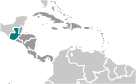
Central America, bordering the North Pacific Ocean, between El Salvador and Mexico, and bordering the Gulf of Honduras (Caribbean Sea) between Honduras and Belize Geographic coordinates
15 30 N, 90 15 W
Map references
Central America and the Caribbean
Area World Ranking: 107
Total 108,889 sq km
Land 107,159 sq km Water 1,730 sq km Area - comparative
Slightly smaller than Tennessee Land boundaries
Total 1,687 km
Border countries Belize 266 km, El Salvador 203 km, Honduras 256 km, Mexico 962 km Coastline
400 km
Maritime claims
Territorial sea 12 nm
Exclusive economic zone 200 nm Continental shelf 200 m depth or to the depth of exploitation Climate
Tropical; hot, humid in lowlands; cooler in highlands Terrain
Mostly mountains with narrow coastal plains and rolling limestone plateau Elevation extremes
Lowest point Pacific Ocean 0 m
Highest point Volcan Tajumulco 4,211 m Note Highest point in Central America Natural resources
Petroleum, nickel, rare woods, fish, chicle, hydropower Land use
Arable land 13.22%
Permanent crops 5.6% Other 81.18% (2005) Irrigated land
2,000 sq km (2003)
Total renewable water resources
111.3 cu km (2000)
Freshwater withdrawal (domestic/industrial/agricultural)
Total 2.01 cu km/yr (6%/13%/80%)
Per capita 160 cu m/yr (2000) Natural hazards
Numerous volcanoes in mountains, with occasional violent earthquakes; Caribbean coast extremely susceptible to hurricanes and other tropical storms Volcanism Significant volcanic activity in the Sierra Madre range; Santa Maria (elev. 3,772 m) has been deemed a "Decade Volcano" by the International Association of Volcanology and Chemistry of the Earth's Interior, worthy of study due to its explosive history and close proximity to human populations; Pacaya (elev. 2,552 m), which erupted in May 2010 causing an ashfall on Guatemala City and prompting evacuations, is one of the country's most active volcanoes with frequent eruptions since 1965; other historically active volcanoes include Acatenango, Almolonga, Atitlan, Fuego, and Tacana Environment - current issues
Deforestation in the Peten rainforest; soil erosion; water pollution Environment - international agreements
Party to
Antarctic Treaty, Biodiversity, Climate Change, Climate Change-Kyoto Protocol, Desertification, Endangered Species, Environmental Modification, Hazardous Wastes, Law of the Sea, Marine Dumping, Ozone Layer Protection, Ship Pollution, Wetlands, Whaling Signed, but not ratified None of the selected agreements Geography - note
No natural harbors on west coast
Comments
Add a new comment: |
Advertisement
Members area
Guatemala (Guatemala City):
 
GPS points from Guatemala (Guatemala City)
|
||||||||

 The Mayan civilization flourished in Guatemala and surrounding regions during the first millennium A.D. After almost three centuries as a Spanish colony, Guatemala won its independence in 1821. During the second half of the 20th century, it experienced a variety of military and civilian governments, as well as a 36-year guerrilla war. In 1996, the government signed a peace agreement formally ending the conflict, which had left more than 200,000 people dead and had created, by some estimates, some 1 million refugees. In January 2012, Guatemala assumed a nonpermanent seat on the UN Security Council for the 2012-13 term.