|
|
Advertisements:
TransportationAirports World Ranking: 160
8 (2012)
Airports - with paved runways
Total 2
Over 3,047 m 1 1,524 to 2,437 m 1 (2012) Airports - with unpaved runways
Total 6
1,524 to 2,437 m 1 914 to 1,523 m 2 Under 914 m 3 (2012) Roadways World Ranking: 161
Total 3,455 km
Paved 965 km Unpaved 2,490 km (2002) Waterways
(rivers are navigable for some distance; many inlets and creeks give shallow-water access to much of interior) (2012) Ports and terminals
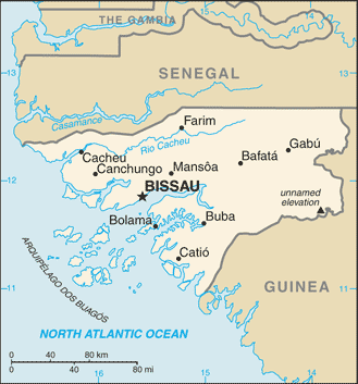
Bissau, Buba, Cacheu, Farim
Comments
Add a new comment: |
Advertisement
Members area
Guinea - Bissau (Bissau):
 
GPS points from Guinea - Bissau (Bissau)
|
||||||||

 Since independence from Portugal in 1974, Guinea-Bissau has experienced considerable political and military upheaval. In 1980, a military coup established authoritarian dictator Joao Bernardo 'Nino' VIEIRA as president. Despite setting a path to a market economy and multiparty system, VIEIRA's regime was characterized by the suppression of political opposition and the purging of political rivals. Several coup attempts through the 1980s and early 1990s failed to unseat him. In 1994 VIEIRA was elected president in the country's first free elections. A military mutiny and resulting civil war in 1998 eventually led to VIEIRA's ouster in May 1999. In February 2000, a transitional government turned over power to opposition leader Kumba YALA after he was elected president in transparent polling. In September 2003, after only three years in office, YALA was ousted by the military in a bloodless coup, and businessman Henrique ROSA was sworn in as interim president. In 2005, former President VIEIRA was re-elected president pledging to pursue economic development and national reconciliation; he was assassinated in March 2009. Malam Bacai SANHA was elected in an emergency election held in June 2009, but he passed away abruptly in January 2012. A military coup on 12 April 2012 prevented Guinea-Bissau's second-round presidential election - to determine SANHA's successor - from taking place.