|
|
|
Advertisements:
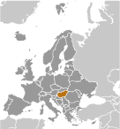
GeographyLocation
Central Europe, northwest of Romania Geographic coordinates
47 00 N, 20 00 E
Map references
Europe
Area World Ranking: 110
Total 93,028 sq km
Land 89,608 sq km Water 3,420 sq km Area - comparative
Slightly smaller than Indiana
Land boundaries
Total 2,185 km
Border countries Austria 366 km, Croatia 329 km, Romania 443 km, Serbia 166 km, Slovakia 676 km, Slovenia 102 km, Ukraine 103 km Coastline
0 km (landlocked)
Maritime claims
None (landlocked)
Climate
Temperate; cold, cloudy, humid winters; warm summers Terrain
Mostly flat to rolling plains; hills and low mountains on the Slovakian border Elevation extremes
Lowest point Tisza River 78 m
Highest point Kekes 1,014 m Natural resources
Bauxite, coal, natural gas, fertile soils, arable land Land use
Arable land 49.58%
Permanent crops 2.06% Other 48.36% (2005) Irrigated land
1,400 sq km (2003)
Total renewable water resources
120 cu km (2005)
Freshwater withdrawal (domestic/industrial/agricultural)
Total 21.03 cu km/yr (9%/59%/32%)
Per capita 2,082 cu m/yr (2001) Environment - current issues
The upgrading of Hungary's standards in waste management, energy efficiency, and air, soil, and water pollution to meet EU requirements will require large investments Environment - international agreements
Party to
Air Pollution, Air Pollution-Nitrogen Oxides, Air Pollution-Persistent Organic Pollutants, Air Pollution-Sulfur 85, Air Pollution-Sulfur 94, Air Pollution-Volatile Organic Compounds, Antarctic Treaty, Biodiversity, Climate Change, Climate Change-Kyoto Protocol, Desertification, Endangered Species, Environmental Modification, Hazardous Wastes, Law of the Sea, Marine Dumping, Ozone Layer Protection, Ship Pollution, Wetlands, Whaling Signed, but not ratified None of the selected agreements Geography - note
Landlocked; strategic location astride main land routes between Western Europe and Balkan Peninsula as well as between Ukraine and Mediterranean basin; the north-south flowing Duna (Danube) and Tisza Rivers divide the country into three large regions
Comments
Add a new comment: |
Advertisement
Members area
Hungary (Budapest):
 
GPS points from Hungary (Budapest)
|
||||||||

 Hungary became a Christian kingdom in A.D. 1000 and for many centuries served as a bulwark against Ottoman Turkish expansion in Europe. The kingdom eventually became part of the polyglot Austro-Hungarian Empire, which collapsed during World War I. The country fell under Communist rule following World War II. In 1956, a revolt and an announced withdrawal from the Warsaw Pact were met with a massive military intervention by Moscow. Under the leadership of Janos KADAR in 1968, Hungary began liberalizing its economy, introducing so-called "Goulash Communism." Hungary held its first multiparty elections in 1990 and initiated a free market economy. It joined NATO in 1999 and the EU five years later. In 2011, Hungary assumed the six-month rotating presidency of the EU for the first time.