|
|
|
Advertisements:
GeographyLocation
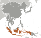
Southeastern Asia, archipelago between the Indian Ocean and the Pacific Ocean Geographic coordinates
5 00 S, 120 00 E
Map references
Southeast Asia
Area World Ranking: 15
Total 1,904,569 sq km
Land 1,811,569 sq km Water 93,000 sq km Area - comparative
Slightly less than three times the size of Texas Land boundaries
Total 2,830 km
Border countries Timor-Leste 228 km, Malaysia 1,782 km, Papua New Guinea 820 km Coastline
54,716 km
Maritime claims
Measured from claimed archipelagic straight baselines Territorial sea 12 nmExclusive economic zone 200 nm Climate
Tropical; hot, humid; more moderate in highlands Terrain
Mostly coastal lowlands; larger islands have interior mountains Elevation extremes
Lowest point Indian Ocean 0 m
Highest point Puncak Jaya 5,030 m Natural resources
Petroleum, tin, natural gas, nickel, timber, bauxite, copper, fertile soils, coal, gold, silver Land use
Arable land 11.03%
Permanent crops 7.04% Other 81.93% (2005) Irrigated land
67,220 sq km (2003)
Total renewable water resources
2,838 cu km (1999)
Freshwater withdrawal (domestic/industrial/agricultural)
Total 82.78 cu km/yr (8%/1%/91%)
Per capita 372 cu m/yr (2000) Natural hazards
Occasional floods; severe droughts; tsunamis; earthquakes; volcanoes; forest fires Volcanism Indonesia contains the most volcanoes of any country in the world - some 76 are historically active; significant volcanic activity occurs on Java, western Sumatra, the Sunda Islands, Halmahera Island, Sulawesi Island, Sangihe Island, and in the Banda Sea; Merapi (elev. 2,968 m), Indonesia's most active volcano and in eruption since 2010, has been deemed a "Decade Volcano" by the International Association of Volcanology and Chemistry of the Earth's Interior, worthy of study due to its explosive history and close proximity to human populations; other notable historically active volcanoes include Agung, Awu, Karangetang, Krakatau (Krakatoa), Makian, Raung, and Tambora Environment - current issues
Deforestation; water pollution from industrial wastes, sewage; air pollution in urban areas; smoke and haze from forest fires Environment - international agreements
Party to
Biodiversity, Climate Change, Climate Change-Kyoto Protocol, Desertification, Endangered Species, Hazardous Wastes, Law of the Sea, Ozone Layer Protection, Ship Pollution, Tropical Timber 83, Tropical Timber 94, Wetlands Signed, but not ratified Marine Life ConservationGeography - note
Archipelago of 17,508 islands (6,000 inhabited); straddles equator; strategic location astride or along major sea lanes from Indian Ocean to Pacific Ocean
Comments
Add a new comment: |
Advertisement
Members area
Indonesia (Jakarta):
 
GPS points from Indonesia (Jakarta)
|
||||||||

 The Dutch began to colonize Indonesia in the early 17th century; Japan occupied the islands from 1942 to 1945. Indonesia declared its independence after Japan's surrender, but it required four years of intermittent negotiations, recurring hostilities, and UN mediation before the Netherlands agreed to transfer sovereignty in 1949. After decades of repressive rule, free and fair legislative elections took place in 1999. Indonesia is now the world's third most populous democracy, the world's largest archipelagic state, and home to the world's largest Muslim population. Current issues include: alleviating poverty, improving education, preventing terrorism, consolidating democracy after four decades of authoritarianism, implementing economic and financial reforms, stemming corruption, reforming the criminal justice system, holding the military and police accountable for human rights violations, addressing climate change, and controlling infectious diseases, particularly those of global and regional importance. In 2005, Indonesia reached a historic peace agreement with armed separatists in Aceh, which led to democratic elections in Aceh in December 2006. Indonesia continues to face low intensity armed resistance by the separatist Free Papua Movement.