|
|
|
Advertisements:
GeographyLocation
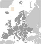
Northern Europe, island between the Greenland Sea and the Norwegian Sea, northeast of Iceland Geographic coordinates
71 00 N, 8 00 W
Map references
Europe
Area World Ranking: 204
Total 377 sq km
Land 377 sq km Water 0 sq km Area - comparative
Slightly more than twice the size of Washington, DC Land boundaries
0 km
Coastline
124.1 km
Maritime claims
Territorial sea 4 nm
Contiguous zone 10 nm Exclusive economic zone 200 nm Continental shelf 200 m depth or to the depth of exploitation Climate
Arctic maritime with frequent storms and persistent fog Terrain
Volcanic island, partly covered by glaciers Elevation extremes
Lowest point Norwegian Sea 0 m
Highest point Haakon VII Toppen on Beerenberg 2,277 m Note Beerenberg volcano has numerous peaks; the highest point on the volcano rim is named Haakon VII Toppen, after Norway's first king following the reestablishment of Norwegian independence in 1905 Natural resources
None
Land use
Arable land 0%
Permanent crops 0% Other 100% (2005) Irrigated land
0 sq km
Natural hazards
Dominated by the volcano Beerenberg Volcanism Beerenberg (elev. 2,227 m) is Norway's only active volcano; volcanic activity resumed in 1970; the most recent eruption occurred in 1985 Environment - current issues
NA
Geography - note
Barren volcanic island with some moss and grass
Comments
Add a new comment: |
Advertisement
Members area
Jan Mayen [ Norway ] (Norway):
 
GPS points from Jan Mayen [ Norway ] (Norway)
|
||||||||

 This desolate, arctic, mountainous island was named after a Dutch whaling captain who indisputably discovered it in 1614 (earlier claims are inconclusive). Visited only occasionally by seal hunters and trappers over the following centuries, the island came under Norwegian sovereignty in 1929. The long dormant Beerenberg volcano, the northernmost active volcano on earth, resumed activity in 1970 and the most recent eruption occurred in 1985.