|
|
|
Advertisements:
GeographyLocation
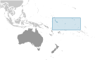
Oceania, group of 33 coral atolls in the Pacific Ocean, straddling the Equator, as well as the International Date Line; the capital Tarawa is about half way between Hawaii and Australia Geographic coordinates
1 25 N, 173 00 E
Map references
Oceania
Area World Ranking: 187
Total 811 sq km
Land 811 sq km Water 0 sq km Note Includes three island groups - Gilbert Islands, Line Islands, Phoenix Islands Area - comparative
Four times the size of Washington, DC Land boundaries
0 km
Coastline
1,143 km
Maritime claims
Territorial sea 12 nm
Exclusive economic zone 200 nm Climate
Tropical; marine, hot and humid, moderated by trade winds Terrain
Mostly low-lying coral atolls surrounded by extensive reefs Elevation extremes
Lowest point Pacific Ocean 0 m
Highest point Unnamed elevation on Banaba 81 m Natural resources
Phosphate (production discontinued in 1979) Land use
Arable land 2.74%
Permanent crops 47.95% Other 49.31% (2005) Irrigated land
NA
Natural hazards
Typhoons can occur any time, but usually November to March; occasional tornadoes; low level of some of the islands make them sensitive to changes in sea level Environment - current issues
Heavy pollution in lagoon of south Tarawa atoll due to heavy migration mixed with traditional practices such as lagoon latrines and open-pit dumping; ground water at risk Environment - international agreements
Party to
Biodiversity, Climate Change, Climate Change-Kyoto Protocol, Desertification, Hazardous Wastes, Law of the Sea, Marine Dumping, Ozone Layer Protection, Whaling Signed, but not ratified None of the selected agreements Geography - note
21 of the 33 islands are inhabited; Banaba (Ocean Island) in Kiribati is one of the three great phosphate rock islands in the Pacific Ocean - the others are Makatea in French Polynesia, and Nauru; Kiribati is the only country in the world to fall into all four hemispheres (northern, southern, eastern, and western)
Comments
Add a new comment: |
Advertisement
Members area
Kiribati (South Tarawa):
 
GPS points from Kiribati (South Tarawa)
|
||||||||

 The Gilbert Islands became a British protectorate in 1892 and a colony in 1915; they were captured by the Japanese in the Pacific War in 1941. The islands of Makin and Tarawa were the sites of major US amphibious victories over entrenched Japanese garrisons in 1943. The Gilbert Islands were granted self-rule by the UK in 1971 and complete independence in 1979 under the new name of Kiribati. The US relinquished all claims to the sparsely inhabited Phoenix and Line Island groups in a 1979 treaty of friendship with Kiribati.