|
|
Advertisements:
GovernmentCountry name
Conventional long form Republic of Kiribati
Conventional short form Kiribati Local long form Republic of Kiribati Local short form Kiribati Note Pronounced keer-ree-bahss Former Gilbert Islands Government type
Republic
Capital
Name Tarawa
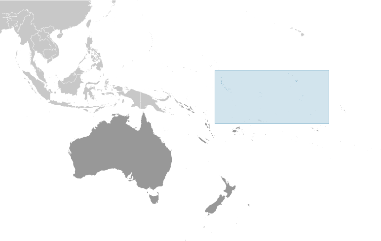
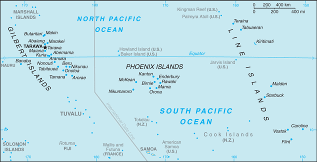
Geographic coordinates 0 53 S, 169 32 E Time difference UTC+12 (17 hours ahead of Washington, DC during Standard Time) Note On 1 January 1995, Kiribati proclaimed that all of its territory was in the same time zone as its Gilbert Islands group (UTC +12) even though the Phoenix Islands and the Line Islands under its jurisdiction were on the other side of the International Date Line Administrative divisions
3 units; Gilbert Islands, Line Islands, Phoenix Islands; note - in addition, there are 6 districts (Banaba, Central Gilberts, Line Islands, Northern Gilberts, Southern Gilberts, Tarawa) and 21 island councils - one for each of the inhabited islands (Abaiang, Abemama, Aranuka, Arorae, Banaba, Beru, Butaritari, Kanton, Kiritimati, Kuria, Maiana, Makin, Marakei, Nikunau, Nonouti, Onotoa, Tabiteuea, Tabuaeran, Tamana, Tarawa, Teraina) Independence
12 July 1979 (from the UK)
Constitution
12 July 1979
Legal system
English common law supplemented by customary law International law organization participation
Has not submitted an ICJ jurisdiction declaration; non-party state to the ICCt Suffrage
18 years of age; universal
Executive branch
Chief of state
President Anote TONG (since 10 July 2003); Vice President Teima ONORIO; note - the president is both the chief of state and head of government Head of government President Anote TONG (since 10 July 2003); Vice President Teima ONORIO Cabinet 12-member cabinet appointed by the president from among the members of the House of Parliament Elections The House of Parliament nominates the presidential candidates from among its members following parliamentary elections and then those candidates compete in a general election; president elected by popular vote for a four-year term (eligible for two more terms); election last held on 13 January 2012 (next to be held in 2015); vice president appointed by the president Election results Anote TONG 42.2%, Tetaua TAITAI 35%, Rimeta BENIAMINA 22.8% Legislative branch
Unicameral House of Parliament or Maneaba Ni Maungatabu (46 seats; 44 members elected by popular vote, 1 ex officio member - the attorney general, 1 nominated by the Rabi Council of Leaders (representing Banaba Island); members serve four-year terms) Elections Legislative elections were held in two rounds - the first round on 21 October 2011 and the second round on 28 October 2011 (next to be held in 2015) Election results Percent of vote by party - NA; seats by party - NA, other 2 (includes attorney general) Judicial branch
Court of Appeal; High Court; 26 Magistrates' courts; judges at all levels are appointed by the president Political parties and leaders
Boutokaan Te Koaua Party or BTK [Taberannang TIMEON]; Maneaban Te Mauri Party or MTM [Teburoro TITO]; Maurin Kiribati Pati or MKP; National Progressive Party or NPP [Dr. Harry TONG] Note There is no tradition of formally organized political parties in Kiribati; they more closely resemble factions or interest groups because they have no party headquarters, formal platforms, or party structures Political pressure groups and leaders
NA
International organization participation
ACP, ADB, AOSIS, C, FAO, IBRD, ICAO, ICRM, IDA, IFAD, IFC, IFRCS, ILO, IMF, IMO, IOC, ITU, ITUC, OPCW, PIF, Sparteca, SPC, UN, UNCTAD, UNESCO, UPU, WHO, WMO Diplomatic representation in the us
Kiribati does not have an embassy in the US; there is an honorary consulate in Honolulu Diplomatic representation from the us
The US does not have an embassy in Kiribati; the US ambassador to Fiji is accredited to Kiribati Flag description
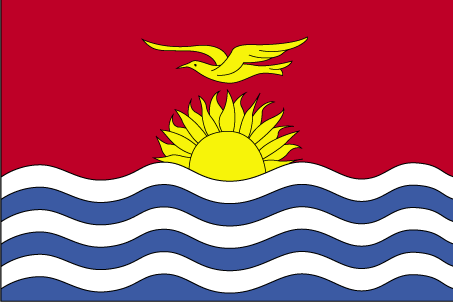
The upper half is red with a yellow frigate bird flying over a yellow rising sun, and the lower half is blue with three horizontal wavy white stripes to represent the Pacific ocean; the white stripes represent the three island groups - the Gilbert, Line, and Phoenix Islands; the 17 rays of the sun represent the 16 Gilbert Islands and Banaba (formerly Ocean Island); the frigate bird symbolizes authority and freedom National symbol(s)
Frigatebird
National anthem
Name
"Teirake kaini Kiribati" (Stand Up, Kiribati) Lyrics/music Urium Tamuera IOTEBANote Adopted 1979
Comments
Add a new comment: |
Advertisement
Members area
Kiribati (South Tarawa):
 
GPS points from Kiribati (South Tarawa)
|
||||||||

 The Gilbert Islands became a British protectorate in 1892 and a colony in 1915; they were captured by the Japanese in the Pacific War in 1941. The islands of Makin and Tarawa were the sites of major US amphibious victories over entrenched Japanese garrisons in 1943. The Gilbert Islands were granted self-rule by the UK in 1971 and complete independence in 1979 under the new name of Kiribati. The US relinquished all claims to the sparsely inhabited Phoenix and Line Island groups in a 1979 treaty of friendship with Kiribati.