|
|
|
Advertisements:
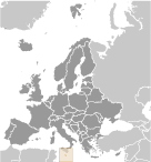
GeographyLocation
Southern Europe, islands in the Mediterranean Sea, south of Sicily (Italy) Geographic coordinates
35 50 N, 14 35 E
Map references
Europe
Area World Ranking: 207
Total 316 sq km
Land 316 sq km Water 0 sq km Area - comparative
Slightly less than twice the size of Washington, DC Land boundaries
0 km
Coastline
196.8 km (excludes 56 km for the island of Gozo) Maritime claims
Territorial sea 12 nm
Contiguous zone 24 nm Continental shelf 200 m depth or to the depth of exploitation Exclusive fishing zone 25 nmClimate
Mediterranean; mild, rainy winters; hot, dry summers Terrain
Mostly low, rocky, flat to dissected plains; many coastal cliffs Elevation extremes
Lowest point Mediterranean Sea 0 m
Highest point Ta'Dmejrek 253 m (near Dingli) Natural resources
Limestone, salt, arable land
Land use
Arable land 31.25%
Permanent crops 3.13% Other 65.62% (2005) Irrigated land
32 sq km (2003)
Total renewable water resources
0.07 cu km (2005)
Freshwater withdrawal (domestic/industrial/agricultural)
Total 0.02 cu km/yr (74%/1%/25%)
Per capita 50 cu m/yr (2000) Natural hazards
NA
Environment - current issues
Limited natural freshwater resources; increasing reliance on desalination Environment - international agreements
Party to
Air Pollution, Biodiversity, Climate Change, Climate Change-Kyoto Protocol, Desertification, Endangered Species, Hazardous Wastes, Law of the Sea, Marine Dumping, Ozone Layer Protection, Ship Pollution, Wetlands Signed, but not ratified None of the selected agreements Geography - note
The country comprises an archipelago, with only the three largest islands (Malta, Ghawdex or Gozo, and Kemmuna or Comino) being inhabited; numerous bays provide good harbors; Malta and Tunisia are discussing the commercial exploitation of the continental shelf between their countries, particularly for oil exploration
Comments
Add a new comment: |
Advertisement
Members area
Malta (Valletta):
 
GPS points from Malta (Valletta)
|
||||||||

 Great Britain formally acquired possession of Malta in 1814. The island staunchly supported the UK through both world wars and remained in the Commonwealth when it became independent in 1964. A decade later Malta became a republic. Since about the mid-1980s, the island has transformed itself into a freight transshipment point, a financial center, and a tourist destination. Malta became an EU member in May 2004 and began using the euro as currency in 2008.