|
|
Advertisements:
TransportationAirports World Ranking: 147
15 (2012)
Airports - with paved runways
Total 4
1,524 to 2,437 m 3 914 to 1,523 m 1 (2012) Airports - with unpaved runways
Total 11
914 to 1,523 m 10 Under 914 m 1 (2012) Roadways World Ranking: 174
Total
2,028 km (includes 75 km of expressways) (2007) Merchant marine World Ranking: 7
Total 1,593
By type Barge carrier 1, bulk carrier 524, cargo 65, carrier 1, chemical tanker 351, container 226, liquefied gas 88, passenger 7, passenger/cargo 1, petroleum tanker 297, refrigerated cargo 13, roll on/roll off 9, vehicle carrier 10 Foreign-owned 1,468 (Belgium 1, Bermuda 35, Brazil 1, Canada 8, China 14, Croatia 12, Cyprus 40, Denmark 7, Egypt 1, France 7, Germany 248, Greece 408, Hong Kong 3, India 10, Indonesia 1, Iraq 2, Ireland 6, Italy 1, Japan 59, Jersey 11, Kuwait 2, Latvia 19, Malaysia 11, Mexico 2, Monaco 30, Netherlands 21, Norway 75, Pakistan 1, Qatar 29, Romania 2, Russia 5, Singapore 30, Slovenia 6, South Korea 41, Sweden 1, Switzerland 12, Taiwan 8, Turkey 70, UAE 12, UK 12, UK 3, Ukraine 1, US 200) (2010) Ports and terminals
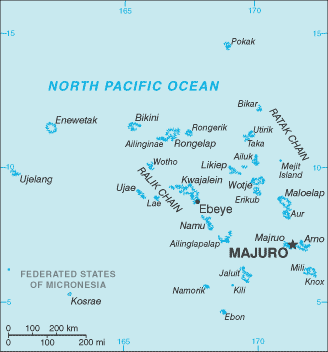
Enitwetak Island, Kwajalein, Majuro
Comments
Add a new comment: |
Advertisement
Members area
Marshall Islands (Majuro):
 
GPS points from Marshall Islands (Majuro)
|
||||||||

 After almost four decades under US administration as the easternmost part of the UN Trust Territory of the Pacific Islands, the Marshall Islands attained independence in 1986 under a Compact of Free Association. Compensation claims continue as a result of US nuclear testing on some of the atolls between 1947 and 1962. The Marshall Islands hosts the US Army Kwajalein Atoll (USAKA) Reagan Missile Test Site, a key installation in the US missile defense network.