|
|
Advertisements:
GovernmentCountry name
Conventional long form Republic of Mauritius
Conventional short form Mauritius Local long form Republic of Mauritius Local short form Mauritius Government type
Parliamentary democracy
Capital
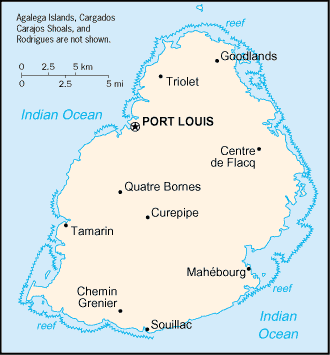
Name Port Louis
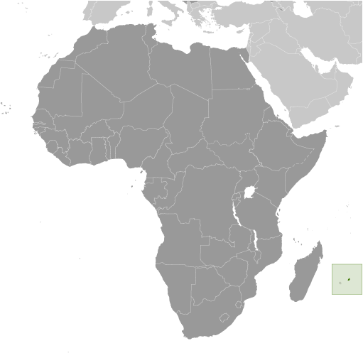
Geographic coordinates 20 09 S, 57 29 E Time difference UTC+4 (9 hours ahead of Washington, DC during Standard Time) Administrative divisions
9 districts and 3 dependencies*; Agalega Islands*, Black River, Cargados Carajos Shoals*, Flacq, Grand Port, Moka, Pamplemousses, Plaines Wilhems, Port Louis, Riviere du Rempart, Rodrigues*, Savanne Independence
12 March 1968 (from the UK)
Constitution
12 March 1968; amended 12 March 1992 Legal system
Civil legal system based on French civil law with some elements of English common law International law organization participation
Accepts compulsory ICJ jurisdiction with reservations; accepts ICCt jurisdiction Suffrage
18 years of age; universal
Executive branch
Chief of state
President Rajkeswur Kailash PURRYAG (since 21 July 2012); note - former President Sir Anerood JUGNAUTH resigned on 31 March 2012 Head of government Prime Minister Navinchandra RAMGOOLAM (since 5 July 2005) Cabinet Council of Ministers appointed by the president on the recommendation of the prime minister Elections President and vice president elected by the National Assembly for five-year terms (eligible for a second term); elections last held on 21 July 2012 (next to be held in 2017); prime minister and deputy prime minister appointed by the president, responsible to the National Assembly; note - former President Sir Anerood JUGNAUTH resigned on 31 March 2012 Election results Rajkeswur Kailash PURRYAG elected president by unanimous vote; percent of vote by the National Assembly - NA Legislative branch
Unicameral National Assembly (70 seats; 62 members elected by popular vote, 8 appointed by the election commission to give representation to various ethnic minorities; members to serve five-year terms) Elections Last held on 5 May 2010 (next to be held in 2015) Election results Percent of vote by party - NA; seats by party - AF 41, MMM 18, MR 2, MSF 1; appointed seats - to be assigned 8 Judicial branch
Supreme Court
Political parties and leaders
Alliance of the Future or AF [Navinchandra RAMGOOLAM] (governing coalition - includes MLP, MMSM, MR, MSD, PMSD); Mauritian Labor Party or MLP [Navinchandra RAMGOOLAM]; Mauritian Militant Movement or MMM [Paul BERENGER]; Mauritian Militant Socialist Movement or MMSM [Pravind JUGNAUTH]; Mauritian Socialist Militant Movement or MSMM [Madan DULLOO]; Mauritian Solidarity Front of FSM [Cehl FAKEERMEEAH]; Mouvement Republicain or MR [Jayarama VALAYDEN]; Maurition Social Democratic Party or PMSD [Xavier Luc DUVAL]; Rodrigues Movement or MR [Joseph (Nicholas) Von MALLY]; Rodrigues Peoples Organization or OPR [Serge CLAIR] Political pressure groups and leaders
Other Various labor unions
International organization participation
ACP, AfDB, AOSIS, AU, C, COMESA, CPLP (associate), FAO, G-77, IAEA, IBRD, ICAO, ICRM, IDA, IFAD, IFC, IFRCS, IHO, ILO, IMF, IMO, IMSO, InOC, Interpol, IOC, IOM, IPU, ISO, ITSO, ITU, ITUC, MIGA, NAM, OIF, OPCW, PCA, SAARC (observer), SADC, UN, UNCTAD, UNESCO, UNIDO, UNWTO, UPU, WCO, WFTU, WHO, WIPO, WMO, WTO Diplomatic representation in the us
Chief of mission Ambassador Somduth SOBORUN
Chancery 1709 N Street NW, Washington, DC 20036; administrative offices - 3201 Connecticut Avenue NW, Suite 441, Washington, DC 20036 Telephone [1] (202) 244-1491 through 1492 FAX [1] (202) 966-0983Diplomatic representation from the us
Chief of mission
Ambassador (vacant); Charge d'Affaires Troy FITRELL Embassy 4th Floor, Rogers House, John Kennedy Street, Port Louis Mailing address International mail: P. O. Box 544, Port Louis; US mail: American Embassy, Port Louis, US Department of State, Washington, DC 20521-2450 Telephone [230] 202-4400FAX [230] 208-9534 Flag description
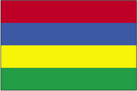
Four equal horizontal bands of red (top), blue, yellow, and green; red represents self-determination and independence, blue the Indian Ocean surrounding the island, yellow has been interpreted as the new light of independence, golden sunshine, or the bright future, and green can symbolize either agriculture or the lush vegetation of the island National anthem
Name "Motherland"
Lyrics/music Jean Georges PROSPER/Philippe GENTIL Note Adopted 1968
Comments
Add a new comment: |
Advertisement
Members area
Mauritius (Port Louis):
 
GPS points from Mauritius (Port Louis)
|
||||||||

 Although known to Arab and Malay sailors as early as the 10th century, Mauritius was first explored by the Portuguese in the 16th century and subsequently settled by the Dutch - who named it in honor of Prince Maurits van NASSAU - in the 17th century. The French assumed control in 1715, developing the island into an important naval base overseeing Indian Ocean trade, and establishing a plantation economy of sugar cane. The British captured the island in 1810, during the Napoleonic Wars. Mauritius remained a strategically important British naval base, and later an air station, playing an important role during World War II for anti-submarine and convoy operations, as well as the collection of signal intelligence. Independence from the UK was attained in 1968. A stable democracy with regular free elections and a positive human rights record, the country has attracted considerable foreign investment and has earned one of Africa's highest per capita incomes.