|
|
|
Advertisements:
GeographyLocation
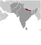
Southern Asia, between China and India Geographic coordinates
28 00 N, 84 00 E
Map references
Asia
Area World Ranking: 94
Total 147,181 sq km
Land 143,351 sq km Water 3,830 sq km Area - comparative
Slightly larger than Arkansas
Land boundaries
Total 2,926 km
Border countries China 1,236 km, India 1,690 km Coastline
0 km (landlocked)
Maritime claims
None (landlocked)
Climate
Varies from cool summers and severe winters in north to subtropical summers and mild winters in south Terrain
Tarai or flat river plain of the Ganges in south, central hill region, rugged Himalayas in north Elevation extremes
Lowest point Kanchan Kalan 70 m
Highest point Mount Everest 8,850 m Natural resources
Quartz, water, timber, hydropower, scenic beauty, small deposits of lignite, copper, cobalt, iron ore Land use
Arable land 16.07%
Permanent crops 0.85% Other 83.08% (2005) Irrigated land
11,680 sq km (2003)
Total renewable water resources
210.2 cu km (1999)
Freshwater withdrawal (domestic/industrial/agricultural)
Total 10.18 cu km/yr (3%/1%/96%)
Per capita 375 cu m/yr (2000) Natural hazards
Severe thunderstorms; flooding; landslides; drought and famine depending on the timing, intensity, and duration of the summer monsoons Environment - current issues
Deforestation (overuse of wood for fuel and lack of alternatives); contaminated water (with human and animal wastes, agricultural runoff, and industrial effluents); wildlife conservation; vehicular emissions Environment - international agreements
Party to
Biodiversity, Climate Change, Climate Change-Kyoto Protocol, Desertification, Endangered Species, Hazardous Wastes, Law of the Sea, Ozone Layer Protection, Tropical Timber 83, Tropical Timber 94, Wetlands Signed, but not ratified Marine Life ConservationGeography - note
Landlocked; strategic location between China and India; contains eight of world's 10 highest peaks, including Mount Everest and Kanchenjunga - the world's tallest and third tallest - on the borders with China and India respectively
Comments
Add a new comment: |
Advertisement
Members area
Nepal (Kathmandu):
 
GPS points from Nepal (Kathmandu)
|
||||||||

 In 1951, the Nepali monarch ended the century-old system of rule by hereditary premiers and instituted a cabinet system of government. Reforms in 1990 established a multiparty democracy within the framework of a constitutional monarchy. An insurgency led by Maoist extremists broke out in 1996. The ensuing 10-year civil war between insurgents and government forces witnessed the dissolution of the cabinet and parliament and assumption of absolute power by the king. Several weeks of mass protests in April 2006 were followed by several months of peace negotiations between the Maoists and government officials, and culminated in a November 2006 peace accord and the promulgation of an interim constitution. Following a nation-wide election in April 2008, the newly formed Constituent Assembly declared Nepal a federal democratic republic and abolished the monarchy at its first meeting the following month. The Constituent Assembly elected the country's first president in July. Between 2008 and 2011 there have been four different coalition governments, led twice by the United Communist Party of Nepal-Maoist, which received a plurality of votes in the Constituent Assembly election, and twice by the Communist Party of Nepal-United Marxist-Leninist. In November 2011, Maoist Prime Minister Baburam BHATTARAI, who was elected in August 2011, and the leaders of the main political parties signed an agreement seeking to conclude the peace process and recommit the Constituent Assembly to finish drafting the constitution by a May 2012 deadline.