|
|
|
Advertisements:
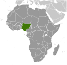
GeographyLocation
Western Africa, bordering the Gulf of Guinea, between Benin and Cameroon Geographic coordinates
10 00 N, 8 00 E
Map references
Africa
Area World Ranking: 32
Total 923,768 sq km
Land 910,768 sq km Water 13,000 sq km Area - comparative
Slightly more than twice the size of California Land boundaries
Total 4,047 km
Border countries Benin 773 km, Cameroon 1,690 km, Chad 87 km, Niger 1,497 km Coastline
853 km
Maritime claims
Territorial sea 12 nm
Exclusive economic zone 200 nm Continental shelf 200 m depth or to the depth of exploitation Climate
Varies; equatorial in south, tropical in center, arid in north Terrain
Southern lowlands merge into central hills and plateaus; mountains in southeast, plains in north Elevation extremes
Lowest point Atlantic Ocean 0 m
Highest point Chappal Waddi 2,419 m Natural resources
Natural gas, petroleum, tin, iron ore, coal, limestone, niobium, lead, zinc, arable land Land use
Arable land 33.02%
Permanent crops 3.14% Other 63.84% (2005) Irrigated land
2,930 sq km (2003)
Total renewable water resources
286.2 cu km (2003)
Freshwater withdrawal (domestic/industrial/agricultural)
Total 8.01 cu km/yr (21%/10%/69%)
Per capita 61 cu m/yr (2000) Natural hazards
Periodic droughts; flooding
Environment - current issues
Soil degradation; rapid deforestation; urban air and water pollution; desertification; oil pollution - water, air, and soil; has suffered serious damage from oil spills; loss of arable land; rapid urbanization Environment - international agreements
Party to
Biodiversity, Climate Change, Climate Change-Kyoto Protocol, Desertification, Endangered Species, Hazardous Wastes, Law of the Sea, Marine Dumping, Marine Life Conservation, Ozone Layer Protection, Ship Pollution, Wetlands Signed, but not ratified None of the selected agreements Geography - note
The Niger enters the country in the northwest and flows southward through tropical rain forests and swamps to its delta in the Gulf of Guinea
Comments
Add a new comment: |
Advertisement
Members area
Nigeria (Abuja):
 
GPS points from Nigeria (Abuja)
|
||||||||

 British influence and control over what would become Nigeria and Africa's most populous country grew through the 19th century. A series of constitutions after World War II granted Nigeria greater autonomy; independence came in 1960. Following nearly 16 years of military rule, a new constitution was adopted in 1999, and a peaceful transition to civilian government was completed. The government continues to face the daunting task of reforming a petroleum-based economy, whose revenues have been squandered through corruption and mismanagement, and institutionalizing democracy. In addition, Nigeria continues to experience longstanding ethnic and religious tensions. Although both the 2003 and 2007 presidential elections were marred by significant irregularities and violence, Nigeria is currently experiencing its longest period of civilian rule since independence. The general elections of April 2007 marked the first civilian-to-civilian transfer of power in the country's history.