|
|
|
Advertisements:
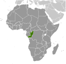
GeographyLocation
Central Africa, bordering the South Atlantic Ocean, between Angola and Gabon Geographic coordinates
1 00 S, 15 00 E
Map references
Africa
Area World Ranking: 64
Total 342,000 sq km
Land 341,500 sq km Water 500 sq km Area - comparative
Slightly smaller than Montana
Land boundaries
Total 5,504 km
Border countries Angola 201 km, Cameroon 523 km, Central African Republic 467 km, Democratic Republic of the Congo 2,410 km, Gabon 1,903 km Coastline
169 km
Maritime claims
Territorial sea 200 nm
Climate
Tropical; rainy season (March to June); dry season (June to October); persistent high temperatures and humidity; particularly enervating climate astride the Equator Terrain
Coastal plain, southern basin, central plateau, northern basin Elevation extremes
Lowest point Atlantic Ocean 0 m
Highest point Mount Berongou 903 m Natural resources
Petroleum, timber, potash, lead, zinc, uranium, copper, phosphates, gold, magnesium, natural gas, hydropower Land use
Arable land 1.45%
Permanent crops 0.15% Other 98.4% (2005) Irrigated land
20 sq km (2003)
Total renewable water resources
832 cu km (1987)
Freshwater withdrawal (domestic/industrial/agricultural)
Total 0.03 cu km/yr (59%/29%/12%)
Per capita 8 cu m/yr (2000) Natural hazards
Seasonal flooding
Environment - current issues
Air pollution from vehicle emissions; water pollution from the dumping of raw sewage; tap water is not potable; deforestation Environment - international agreements
Party to
Biodiversity, Climate Change, Climate Change-Kyoto Protocol, Desertification, Endangered Species, Hazardous Wastes, Law of the Sea, Ozone Layer Protection, Ship Pollution, Tropical Timber 83, Tropical Timber 94, Wetlands Signed, but not ratified None of the selected agreements Geography - note
About 70% of the population lives in Brazzaville, Pointe-Noire, or along the railroad between them
Comments
Add a new comment: |
Advertisement
Members area
Republic Of The Congo (Brazzaville):
 
GPS points from Republic Of The Congo (Brazzaville)
|
||||||||

 Upon independence in 1960, the former French region of Middle Congo became the Republic of the Congo. A quarter century of experimentation with Marxism was abandoned in 1990 and a democratically elected government took office in 1992. A brief civil war in 1997 restored former Marxist President Denis SASSOU-Nguesso, and ushered in a period of ethnic and political unrest. Southern-based rebel groups agreed to a final peace accord in March 2003, but the calm is tenuous and refugees continue to present a humanitarian crisis. The Republic of Congo was once one of Africa's largest petroleum producers, but with declining production it will need new offshore oil finds to sustain its oil earnings over the long term.