|
|
Advertisements:
GovernmentCountry name
Conventional long form None
Conventional short form Saint Lucia Government type
Parliamentary democracy and a Commonwealth realm Capital
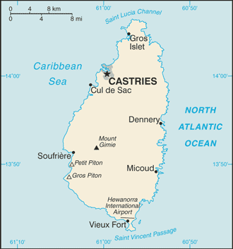
Name Castries
Geographic coordinates 14 00 N, 61 00 W Time difference UTC-4 (1 hour ahead of Washington, DC during Standard Time) Administrative divisions
11 quarters; Anse-la-Raye, Castries, Choiseul, Dauphin, Dennery, Gros-Islet, Laborie, Micoud, Praslin, Soufriere, Vieux-Fort Independence
22 February 1979 (from the UK)
Constitution
22 February 1979
Legal system
English common law
International law organization participation
Has not submitted an ICJ jurisdiction declaration; accepts ICCt jurisdiction Suffrage
18 years of age; universal
Executive branch
Chief of state
Queen ELIZABETH II (since 6 February 1952); represented by Governor General Dame Pearlette LOUISY (since September 1997) Head of government Prime Minister Kenny Davis ANTHONY (since 30 November 2011) Cabinet Cabinet appointed by the governor general on the advice of the prime minister Elections The monarchy is hereditary; the governor general appointed by the monarch; following legislative elections, the leader of the majority party or the leader of a majority coalition usually appointed prime minister by the governor general; deputy prime minister appointed by the governor general Legislative branch
Bicameral Parliament consists of the Senate (11 seats; six members appointed on the advice of the prime minister, three on the advice of the leader of the opposition, and two after consultation with religious, economic, and social groups) and the House of Assembly (17 seats; members elected by popular vote to serve five-year terms) Elections House of Assembly - last held on 28 November 2011 (next to be held in 2016) Election results House of Assembly - percent of vote by party - SLP 51%, UWP 47%; seats by party - SLP 11, UWP 6 Judicial branch
Eastern Caribbean Supreme Court (consists of a High Court and a Court of Appeals; based on Saint Lucia; three judges of the Supreme Court reside in Saint Lucia); member of the Caribbean Court of Justice (CCJ) Political parties and leaders
National Alliance or NA [George ODLUM]; Saint Lucia Freedom Party or SFP [Martinus FRANCOIS]; Saint Lucia Labor Party or SLP [Kenneth ANTHONY]; Sou Tout Apwe Fete Fini or STAFF [Christopher HUNTE]; United Workers Party or UWP [Stephenson KING] Political pressure groups and leaders
NA
International organization participation
ACP, AOSIS, C, Caricom, CDB, CELAC, FAO, G-77, IBRD, ICAO, ICRM, IDA, IFAD, IFC, IFRCS, ILO, IMF, IMO, Interpol, IOC, ISO, ITU, ITUC, MIGA, NAM, OAS, OECS, OIF, OPANAL, OPCW, Petrocaribe, UN, UNCTAD, UNESCO, UNIDO, UPU, WCO, WFTU, WHO, WIPO, WMO, WTO Diplomatic representation in the us
Chief of mission Ambassador Michael LOUIS
Chancery 3216 New Mexico Avenue NW, Washington, DC 20016 Telephone [1] (202) 364-6792 through 6795 FAX [1] (202) 364-6723Consulate(s) general Miami, New York Diplomatic representation from the us
The US does not have an embassy in Saint Lucia; the US Ambassador to Barbados is accredited to Saint Lucia Flag description
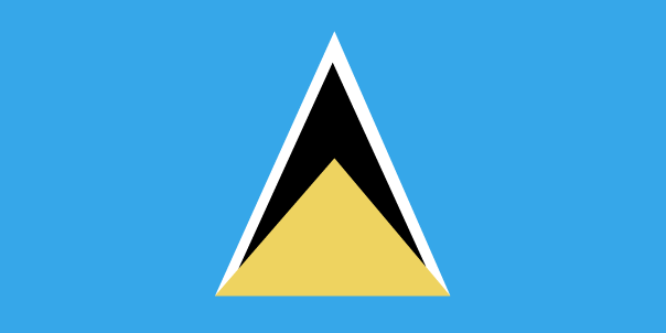
Blue, with a gold isosceles triangle below a black arrowhead; the upper edges of the arrowhead have a white border; the blue color represents the sky and sea, gold stands for sunshine and prosperity, and white and black the racial composition of the island (with the latter being dominant); the two major triangles invoke the twin Pitons (Gros Piton and Petit Piton), cone-shaped volcanic plugs that are a symbol of the island National symbol(s)
Twin pitons (volcanic peaks); Saint Lucia parrot National anthem
Name
"Sons and Daughters of St. Lucia" Lyrics/music Charles JESSE/Leton Felix THOMAS Note Adopted 1967
Comments
Add a new comment: |
Advertisement
Members area
Saint Lucia (Castries):
 
GPS points from Saint Lucia (Castries)
|
||||||||

 The island, with its fine natural harbor at Castries, was contested between England and France throughout the 17th and early 18th centuries (changing possession 14 times); it was finally ceded to the UK in 1814. Even after the abolition of slavery on its plantations in 1834, Saint Lucia remained an agricultural island, dedicated to producing tropical commodity crops. Self-government was granted in 1967 and independence in 1979.