|
|
|
Advertisements:
GeographyLocation
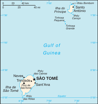
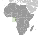
Central Africa, islands in the Gulf of Guinea, straddling the Equator, west of Gabon Geographic coordinates
1 00 N, 7 00 E
Map references
Africa
Area World Ranking: 185
Total 964 sq km
Land 964 sq km Water 0 sq km Area - comparative
More than five times the size of Washington, DC Land boundaries
0 km
Coastline
209 km
Maritime claims
Measured from claimed archipelagic baselines Territorial sea 12 nmExclusive economic zone 200 nm Climate
Tropical; hot, humid; one rainy season (October to May) Terrain
Volcanic, mountainous
Elevation extremes
Lowest point Atlantic Ocean 0 m
Highest point Pico de Sao Tome 2,024 m Natural resources
Fish, hydropower
Land use
Arable land 8.33%
Permanent crops 48.96% Other 42.71% (2005) Irrigated land
100 sq km (2003)
Natural hazards
NA
Environment - current issues
Deforestation; soil erosion and exhaustion Environment - international agreements
Party to
Biodiversity, Climate Change, Climate Change-Kyoto Protocol, Desertification, Endangered Species, Environmental Modification, Law of the Sea, Ozone Layer Protection, Ship Pollution, Wetlands Signed, but not ratified None of the selected agreements Geography - note
The smallest country in Africa; the two main islands form part of a chain of extinct volcanoes and both are mountainous
Comments
Add a new comment: |
Advertisement
Members area
Sao Tome And Principe (Sao Tome):
GPS points from Sao Tome And Principe (Sao Tome)
|
||||||||
 Discovered and claimed by Portugal in the late 15th century, the islands' sugar-based economy gave way to coffee and cocoa in the 19th century - all grown with plantation slave labor, a form of which lingered into the 20th century. While independence was achieved in 1975, democratic reforms were not instituted until the late 1980s. The country held its first free elections in 1991, but frequent internal wrangling between the various political parties precipitated repeated changes in leadership and two failed coup attempts in 1995 and 2003. The recent discovery of oil in the Gulf of Guinea promises to attract increased attention to the small island nation.