|
|
Advertisements:
GovernmentCountry name
Conventional long form Commonwealth of The Bahamas
Conventional short form The Bahamas Government type
Constitutional parliamentary democracy and a Commonwealth realm Capital
Name Nassau
Geographic coordinates 25 05 N, 77 21 W Time difference UTC-5 (same time as Washington, DC during Standard Time) Daylight saving time +1hr, begins second Sunday in March; ends first Sunday in November Administrative divisions
31 districts; Acklins Islands, Berry Islands, Bimini, Black Point, Cat Island, Central Abaco, Central Andros, Central Eleuthera, City of Freeport, Crooked Island and Long Cay, East Grand Bahama, Exuma, Grand Cay, Harbour Island, Hope Town, Inagua, Long Island, Mangrove Cay, Mayaguana, Moore's Island, North Abaco, North Andros, North Eleuthera, Ragged Island, Rum Cay, San Salvador, South Abaco, South Andros, South Eleuthera, Spanish Wells, West Grand Bahama Independence
10 July 1973 (from the UK)
National holiday
Independence Day, 10 July (1973) Constitution
10 July 1973
Legal system
Common law system based on the English model International law organization participation
Has not submitted an ICJ jurisdiction declaration; non-party state to the ICCt Suffrage
18 years of age; universal
Executive branch
Chief of state
Queen ELIZABETH II (since 6 February 1952); represented by Governor General Sir Arthur A. FOULKES (since 14 April 2010) Head of government Prime Minister Perry CHRISTIE (since 8 May 2011) Cabinet Cabinet appointed by the governor general on the prime minister's recommendation Elections The monarchy is hereditary; governor general appointed by the monarch; following legislative elections, the leader of the majority party or the leader of the majority coalition is usually appointed prime minister by the governor general; the prime minister recommends the deputy prime minister Legislative branch
Bicameral Parliament consists of the Senate (16 seats; members appointed by the governor general upon the advice of the prime minister and the opposition leader to serve five-year terms) and the House of Assembly (41 seats; members elected by direct popular vote to serve five-year terms); the government may dissolve the parliament and call elections at any time Elections Last held on 7 May 2012 (next to be held by May 2017) Election results Percent of vote by party - NA; seats by party - PLP 29, FNM 9 Judicial branch
Privy Council in London; Courts of Appeal; Supreme (lower) Court; Magistrates' Courts Political parties and leaders
Free National Movement or FNM [Hubert INGRAHAM]; Progressive Liberal Party or PLP [Perry CHRISTIE] Political pressure groups and leaders
Friends of the Environment
Other Trade unions International organization participation
ACP, AOSIS, C, Caricom, CDB, CELAC, FAO, G-77, IADB, IBRD, ICAO, ICRM, IDA, IFAD, IFC, IFRCS, ILO, IMF, IMO, IMSO, Interpol, IOC, IOM, ITSO, ITU, LAES, MIGA, NAM, OAS, OPANAL, OPCW, Petrocaribe, UN, UNCTAD, UNESCO, UNIDO, UNWTO, UPU, WCO, WHO, WIPO, WMO, WTO (observer) Diplomatic representation in the us
Chief of mission Ambassador Cornelius A. SMITH
Chancery 2220 Massachusetts Avenue NW, Washington, DC 20008 Telephone [1] (202) 319-2660FAX [1] (202) 319-2668 Consulate(s) general Miami, New York Diplomatic representation from the us
Chief of mission Ambassador Nicole A. AVANT
Embassy 42 Queen Street, Nassau, New Providence Mailing address Local or express mail address: P. O. Box N-8197, Nassau; US Department of State, 3370 Nassau Place, Washington, DC 20521-3370 Telephone [1] (242) 322-1181, 328-2206 (after hours) FAX [1] (242) 328-2206Flag description
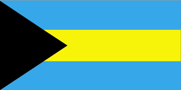
Three equal horizontal bands of aquamarine (top), gold, and aquamarine, with a black equilateral triangle based on the hoist side; the band colors represent the golden beaches of the islands surrounded by the aquamarine sea; black represents the vigor and force of a united people, while the pointing triangle indicates the enterprise and determination of the Bahamian people to develop the rich resources of land and sea National symbol(s)
Blue marlin; flamingo
National anthem
Name "March On, Bahamaland!"
Lyrics/music Timothy GIBSON Note Adopted 1973; as a Commonwealth country, in addition to the national anthem, "God Save the Queen" serves as the royal anthem (see United Kingdom)
Comments
Add a new comment: |
Advertisement
Members area
The Bahamas (Nassau):
 
GPS points from The Bahamas (Nassau)
|
||||||||

 Lucayan Indians inhabited the islands when Christopher COLUMBUS first set foot in the New World on San Salvador in 1492. British settlement of the islands began in 1647; the islands became a colony in 1783. Since attaining independence from the UK in 1973, The Bahamas has prospered through tourism and international banking and investment management. Because of its geography, the country is a major transshipment point for illegal drugs, particularly shipments to the US and Europe, and its territory is used for smuggling illegal migrants into the US.