|
|
|
Advertisements:
GeographyLocation
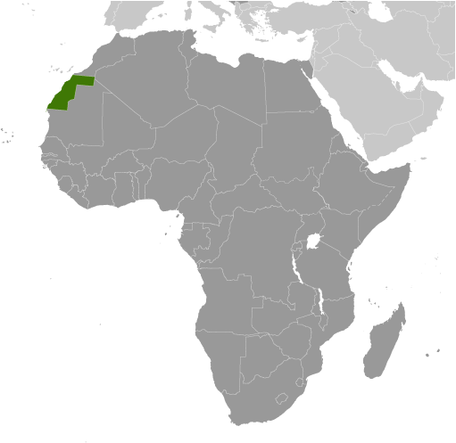
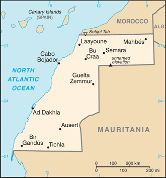
Northern Africa, bordering the North Atlantic Ocean, between Mauritania and Morocco Geographic coordinates
24 30 N, 13 00 W
Map references
Africa
Area World Ranking: 78
Total 266,000 sq km
Land 266,000 sq km Water 0 sq km Area - comparative
About the size of Colorado
Land boundaries
Total 2,046 km
Border countries Algeria 42 km, Mauritania 1,561 km, Morocco 443 km Coastline
1,110 km
Maritime claims
Contingent upon resolution of sovereignty issue Climate
Hot, dry desert; rain is rare; cold offshore air currents produce fog and heavy dew Terrain
Mostly low, flat desert with large areas of rocky or sandy surfaces rising to small mountains in south and northeast Elevation extremes
Lowest point Sebjet Tah -55 m
Highest point Unnamed elevation 805 m Natural resources
Phosphates, iron ore
Land use
Arable land 0.02%
Permanent crops 0% Other 99.98% (2005) Irrigated land
NA
Natural hazards
Hot, dry, dust/sand-laden sirocco wind can occur during winter and spring; widespread harmattan haze exists 60% of time, often severely restricting visibility Environment - current issues
Sparse water and lack of arable land Environment - international agreements
Party to
None of the selected agreements Geography - note
The waters off the coast are particularly rich fishing areas
Comments
Add a new comment: |
Advertisement
Members area
Western Sahara [ Undetermined ] (El Aaiun):
GPS points from Western Sahara [ Undetermined ] (El Aaiun)
|
||||||||
 Morocco annexed the northern two-thirds of Western Sahara (formerly Spanish Sahara) in 1976 and claimed the rest of the territory in 1979, following Mauritania's withdrawal. A guerrilla war with the Polisario Front contesting Morocco's sovereignty ended in a 1991 UN-brokered cease-fire and the nearly 1,700 mile-long defensive sand berm built by the Moroccans from 1980 to 1987 separates the opposing forces with Morocco controlling the roughly 80 percent of the territory west of the berm. A UN-organized referendum on the territory's final status has been repeatedly postponed. The UN since 2007 has sponsored intermittent talks between representatives of the Government of Morocco and the Polisario Front to negotiate the status of Western Sahara. Morocco has put forward an autonomy proposal for the territory, which would allow for some local administration while maintaining Moroccan sovereignty. The Polisario, with Algeria's support, demands a popular referendum that includes the option of independence. Ethnic tensions in Western Sahara occasionally erupt into violence requiring a Moroccan security force response.