|
|
Advertisements:
GeographyLocation
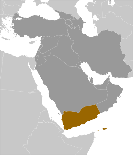
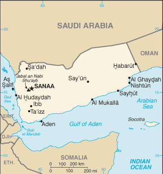
Middle East, bordering the Arabian Sea, Gulf of Aden, and Red Sea, between Oman and Saudi Arabia Geographic coordinates
15 00 N, 48 00 E
Map references
Middle East
Area World Ranking: 50
Total 527,968 sq km
Land 527,968 sq km Water 0 sq km Note Includes Perim, Socotra, the former Yemen Arab Republic (YAR or North Yemen), and the former People's Democratic Republic of Yemen (PDRY or South Yemen) Area - comparative
Slightly larger than twice the size of Wyoming Land boundaries
Total 1,746 km
Border countries Oman 288 km, Saudi Arabia 1,458 km Coastline
1,906 km
Maritime claims
Territorial sea 12 nm
Contiguous zone 24 nm Exclusive economic zone 200 nm Continental shelf 200 nm or to the edge of the continental margin Climate
Mostly desert; hot and humid along west coast; temperate in western mountains affected by seasonal monsoon; extraordinarily hot, dry, harsh desert in east Terrain
Narrow coastal plain backed by flat-topped hills and rugged mountains; dissected upland desert plains in center slope into the desert interior of the Arabian Peninsula Elevation extremes
Lowest point Arabian Sea 0 m
Highest point Jabal an Nabi Shu'ayb 3,760 m Natural resources
Petroleum, fish, rock salt, marble; small deposits of coal, gold, lead, nickel, and copper; fertile soil in west Land use
Arable land 2.91%
Permanent crops 0.25% Other 96.84% (2005) Irrigated land
6,800 sq km (2003)
Total renewable water resources
4.1 cu km (1997)
Freshwater withdrawal (domestic/industrial/agricultural)
Total 6.63 cu km/yr (4%/1%/95%)
Per capita 316 cu m/yr (2000) Natural hazards
Sandstorms and dust storms in summer Volcanism Limited volcanic activity; Jebel at Tair (Jabal al-Tair, Jebel Teir, Jabal al-Tayr, Jazirat at-Tair) (elev. 244 m), which forms an island in the Red Sea, erupted in 2007 after awakening from dormancy; other historically active volcanoes include Harra of Arhab, Harras of Dhamar, Harra es-Sawad, and Jebel Zubair, although many of these have not erupted in over a century Environment - current issues
Limited natural freshwater resources; inadequate supplies of potable water; overgrazing; soil erosion; desertification Environment - international agreements
Party to
Biodiversity, Climate Change, Climate Change-Kyoto Protocol, Desertification, Endangered Species, Environmental Modification, Hazardous Wastes, Law of the Sea, Ozone Layer Protection Signed, but not ratified None of the selected agreements Geography - note
Strategic location on Bab el Mandeb, the strait linking the Red Sea and the Gulf of Aden, one of world's most active shipping lanes
Comments
Add a new comment: |
Advertisement
Members area
Yemen (Sanaa):
 
GPS points from Yemen (Sanaa)
|
||||||||

 North Yemen became independent of the Ottoman Empire in 1918. The British, who had set up a protectorate area around the southern port of Aden in the 19th century, withdrew in 1967 from what became South Yemen. Three years later, the southern government adopted a Marxist orientation. The massive exodus of hundreds of thousands of Yemenis from the south to the north contributed to two decades of hostility between the states. The two countries were formally unified as the Republic of Yemen in 1990. A southern secessionist movement in 1994 was quickly subdued. In 2000, Saudi Arabia and Yemen agreed to a delimitation of their border. Fighting in the northwest between the government and Huthi rebels, a group seeking a return to traditional Zaydi Islam, began in 2004 and has since resulted in six rounds of fighting - the last ended in early 2010 with a ceasefire that continues to hold. The southern secessionist movement was revitalized in 2008 when a popular socioeconomic protest movement initiated the prior year took on political goals including secession. Public rallies in Sana'a against President SALIH - inspired by similar demonstrations in Tunisia and Egypt - slowly built momentum starting in late January 2011 fueled by complaints over high unemployment, poor economic conditions, and corruption. By the following month, some protests had resulted in violence, and the demonstrations had spread to other major cities. By March the opposition had hardened its demands and was unifying behind calls for SALIH's immediate ouster. The Gulf Cooperation Council (GCC) in late April 2011, in an attempt to mediate the crisis in Yemen, proposed an agreement in which the president would step down in exchange for immunity from prosecution. SALIH's refusal to sign an agreement led to heavy street fighting and his injury in an explosion in June 2011. The UN Security Council passed Resolution 2014 in October 2011 calling on both sides to end the violence and complete a power transfer deal. In late November 2011, President SALIH signed the GCC-brokered agreement to step down and to transfer some of his powers to Vice President Abd al-Rabuh Mansur HADI. Following elections in February 2012, won by HADI, SALIH formally transferred his powers.