42°31'60" N
1°30'0" E
~1,357m asl
04:22 (CEST - UTC/GMT+2)
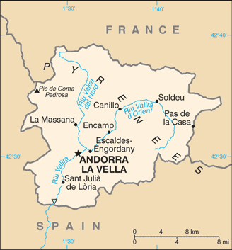
Cami del Cortal de la Serra (Camí del Cortal de la Serra) is a trail (class R - Streets/Highways/Roads) in Andorra (general), Andorra (Europe) with the region font code of Americas/Western Europe. It is located at an elevation of 1,357 meters above sea level.
Its coordinates are 42°31'60" N and 1°30'0" E in DMS (Degrees Minutes Seconds) or 42.5333 and 1.5 (in decimal degrees). Its UTM position is CH71 and its Joint Operation Graphics reference is NK31-04.
Current local time is 04:22; the sun rises at 07:55 and sets at 20:02 local time (Europe/Andorra UTC/GMT+2). The standard time zone for Cami del Cortal de la Serra is UTC/GMT+1, but since Daylight Saving Time (DST) is in effect the current time zone is UTC/GMT+2.
In 2024 DST starts on 31 Mar 2024 and ends on 27 Oct 2024.
A Trail is a path, track, or route used by pedestrians, animals, or off-road vehicles.
|
Advertisements:
Advertisements:
|
Weather Camí del Cortal de la Serra (Cloud cover, Temperature, Wind speed and Precipitation mm probab.)
Mon
Apr 15
~5 l/m2 54%
5 °C min
10 °C max
7 km/h
Thu Jan 1
|
Tue
Apr 16
-2 °C min
8 °C max
16 km/h
Thu Jan 1
|
Wed
Apr 17
-6 °C min
6 °C max
17 km/h
Thu Jan 1
|
Thu
Apr 18
-6 °C min
3 °C max
15 km/h
Thu Jan 1
|
Fri
Apr 19
-9 °C min
8 °C max
14 km/h
Thu Jan 1
|
Sat
Apr 20
-4 °C min
10 °C max
14 km/h
Thu Jan 1
|
|
|
Vedat dels Plans (Andorra (general)) 7 day forecast
Map and Photos Cami del Cortal de la Serra
--- There are no comments yet ---
Add a new comment:
|
Members area
Andorra (Andorra La Vella):
Advertisement
GPS points near Camí del Cortal de la...
GPS points from Andorra (Andorra La Vella)
 Erez Parroquia De La Massana
|