English   Română   Español   Français   Deutsch  

getamap.net

Africa

Oceania

Asia

North America

Europe

South America

Antarctica


The Forest

(The Quarter) / Anguilla (general)

18°12'0" N
63°1'60" W
~0m asl
19:01 (AST - UTC/GMT--4)

The Forest (The Forest) is a populated locality (class P - Populated Place) in Anguilla (general), Anguilla [ United Kingdom ] (North America) with the region font code of Americas/Western Europe.. and its population amounts to 3,292.

Its coordinates are 18°12'0" N and 63°1'60" W in DMS (Degrees Minutes Seconds) or 18.2 and -63.0333 (in decimal degrees). Its UTM position is MF91 and its Joint Operation Graphics reference is NE20-06.

Current local time is 19:01; the sun rises at 08:54 and sets at 21:01 local time (America/Anguilla UTC/GMT-4). The standard time zone for The Forest is UTC/GMT-4
In 2024 DST starts on - and ends on -.

A Populated locality is an area similar to a locality but with a small group of dwellings or other buildings.


Country
 Advertisements:


 Advertisements:


Weather The Forest (Cloud cover, Temperature, Wind speed and Precipitation mm probab.)

Thu


Apr 25
Clound 0-10-0-30
 
26 °C min
28 °C max
29 km/h
Thu Jan 1

Fri


Apr 26
Clound 20-10-20-100
~4 l/m2 49%
 
26 °C min
27 °C max
29 km/h
Thu Jan 1

Sat


Apr 27
Clound 10-10-80-90 Lightning
 
26 °C min
27 °C max
26 km/h
Thu Jan 1

Sun


Apr 28
Clound 30-10-40-100 Lightning
~7 l/m2 55%
 
26 °C min
27 °C max
30 km/h
Thu Jan 1

Mon


Apr 29
Clound 50-30-0-0 Mist Lightning
~10 l/m2 50%
 
25 °C min
26 °C max
34 km/h
Thu Jan 1

Tue


Apr 30
Clound 30-90-10-50 Mist Lightning
~2 l/m2 52%
 
25 °C min
26 °C max
37 km/h
Thu Jan 1

Weather Graph

The Quarter (Anguilla (general)) 7 day forecast
 

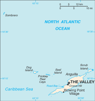
Map and Photos The Forest


Comments

--- There are no comments yet ---


Add a new comment:


You have to log in to add a comment!


Members area


Register

Forgot password?

Anguilla [ United Kingdom ] (Overseas Territory):

Advertisement


GPS points near The Forest

square Burrowes Park (1 km)

square Long Ground (1 km)

square Wallblake (1 km)


square Cauls Bottom (1 km)

square Cauls Pond (1 km)

square Forest Bay (1 km)

square Long Pond (1 km)


square Stoney Ground (1 km)

square Wattices (1 km)

square Long Path (2 km)


square Anguilla (2 km)

square Anguilla (2 km)

square North Side (2 km)

square The Valley (2 km)


GPS points from Anguilla [ United Kingdom ] (Overseas Territory)

square Dowling Anguilla (general)

square South Hill Village Anguilla (general)

square Benzies Bay Anguilla (general)

square Stoney Cove Anguilla (general)

square Wallblake Anguilla (general)

square Anegada Passage Anguilla (general)

square Windward Point Anguilla (general)

square Deadman's Cay Anguilla (general)


viewweather.com sv.ViewWeather.com
fr.ViewWeather.com
da.ViewWeather.com
de.ViewWeather.com
es.ViewWeather.com
www.carpati.org
www.searchromania.net
Deblocari usi
es.getamap.org
fr.getamap.org
de.getamap.org
nl.getamap.org
da.getamap.org
www.getamap.org
Links
Terms of use
Privacy policy

# 0.0647 sec 

contact AT getamap.net

© 2006 - 2024  https://www.getamap.net/