26°49'60" N
89°34'60" E
~795m asl
20:07 (BTT - UTC/GMT+6)
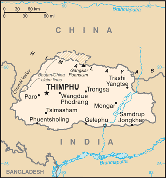
Timbu (Timbu) is a section of stream (class H - Hydrographic) in Bhutan (general), Bhutan (Asia) with the region font code of Asia/Pacific. It is located at an elevation of 795 meters above sea level.
Timbu is also known as Chhuka, Chin Chu, Thimbu, Timbu, Wong, Wong Chu.
Its coordinates are 26°49'60" N and 89°34'60" E in DMS (Degrees Minutes Seconds) or 26.8333 and 89.5833 (in decimal degrees). Its UTM position is YK57 and its Joint Operation Graphics reference is NG45-08.
Current local time is 20:07; the sun rises at 08:55 and sets at 21:02 local time (Asia/Thimphu UTC/GMT+6). The standard time zone for Timbu is UTC/GMT+6
In 2024 DST starts on - and ends on -.
|
Advertisements:
Advertisements:
|
Weather Timbu (Cloud cover, Temperature, Wind speed and Precipitation mm probab.)
Sat
Apr 20
~2 l/m2 47%
18 °C min
21 °C max
10 km/h
Thu Jan 1
|
Sun
Apr 21
15 °C min
27 °C max
15 km/h
Thu Jan 1
|
Mon
Apr 22
16 °C min
28 °C max
18 km/h
Thu Jan 1
|
Tue
Apr 23
16 °C min
30 °C max
17 km/h
Thu Jan 1
|
Wed
Apr 24
16 °C min
30 °C max
17 km/h
Thu Jan 1
|
Thu
Apr 25
~1 l/m2 12%
16 °C min
27 °C max
16 km/h
Thu Jan 1
|
|
|
Wong Chu (Bhutan (general)) 7 day forecast
--- There are no comments yet ---
Add a new comment:
|
Members area
Bhutan (Thimphu):
Advertisement
GPS points near Timbu
GPS points from Bhutan (Thimphu)
|
 Tala (4 km)