English   Română   Español   Français   Deutsch  

getamap.net

Africa

Oceania

Asia

North America

Europe

South America

Antarctica


Le Machoiran Blanc

/ French Guiana (general)

4°55'60" N
52°16'0" W
~0m asl
21:12 (GFT - UTC/GMT--3)

Le Machoiran Blanc (Le Machoiran Blanc) is a rock (class T - Hypsographic) in French Guiana (general), French Guiana [ France ] (South America) with the region font code of Americas/Western Europe...

Its coordinates are 4°55'60" N and 52°16'0" W in DMS (Degrees Minutes Seconds) or 4.93333 and -52.2667 (in decimal degrees). Its UTM position is CL54 and its Joint Operation Graphics reference is NB22-14.

Current local time is 21:12; the sun rises at 08:55 and sets at 21:02 local time (America/Cayenne UTC/GMT-3). The standard time zone for Le Machoiran Blanc is UTC/GMT-3
In 2024 DST starts on - and ends on -.

A Rock is a conspicuous, isolated rocky mass.


Country
 Advertisements:


 Advertisements:


Weather Le Machoiran Blanc (Cloud cover, Temperature, Wind speed and Precipitation mm probab.)

Thu


Apr 18
Clound 60-40-100-100 Mist Lightning
~48 l/m2 96%
 
25 °C min
27 °C max
16 km/h
Thu Jan 1

Fri


Apr 19
Clound 30-30-60-100 Mist Lightning
~22 l/m2 96%
 
25 °C min
29 °C max
25 km/h
Thu Jan 1

Sat


Apr 20
Clound 20-30-0-100
~0.4 l/m2 23%
 
25 °C min
29 °C max
22 km/h
Thu Jan 1

Sun


Apr 21
Clound 50-60-70-100 Mist Lightning
~81 l/m2 97%
 
23 °C min
26 °C max
24 km/h
Thu Jan 1

Mon


Apr 22
Clound 50-40-70-100 Mist Lightning
~23 l/m2 86%
 
24 °C min
28 °C max
25 km/h
Thu Jan 1

Tue


Apr 23
Clound 30-60-10-50 Lightning
~1 l/m2 49%
 
25 °C min
29 °C max
27 km/h
Thu Jan 1

Weather Graph

Le Machoiran Blanc (French Guiana (general)) 7 day forecast
 

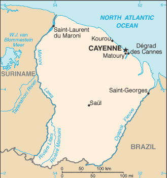
Map and Photos Le Machoiran Blanc


Comments

--- There are no comments yet ---


Add a new comment:


You have to log in to add a comment!


Members area


Register

Forgot password?

Advertisement


GPS points near Le Machoiran Blanc

square Bourda (1 km)

square Mont Bourda (1 km)

square Susini (1 km)

square Suzini (1 km)

square Mont Joli (1 km)

square Montjoli (1 km)

square Montjoly (1 km)


square Montravel (1 km)


square Mont Almaric (2 km)

square Mont Amalric (2 km)


square Trou Biron (3 km)


GPS points from French Guiana [ France ] (Overseas Department)

square Crique Sacaranque French Guiana (general)

square Degrad Nicole French Guiana (general)

square Crique Porotaye French Guiana (general)

square Hopital Jean Martial French Guiana (general)

square Saut Pakou Akara French Guiana (general)

square Crique Nationale French Guiana (general)

square Crique Montagne Penchee French Guiana (general)

square Crique Landeau French Guiana (general)


viewweather.com sv.ViewWeather.com
fr.ViewWeather.com
da.ViewWeather.com
de.ViewWeather.com
es.ViewWeather.com
www.carpati.org
www.searchromania.net
Deblocari usi
es.getamap.org
fr.getamap.org
de.getamap.org
nl.getamap.org
da.getamap.org
www.getamap.org
Links
Terms of use
Privacy policy

# 0.0832 sec 

contact AT getamap.net

© 2006 - 2024  https://www.getamap.net/