|
|
|
Dhahrat Umm `Amir
Weather Dhahrat Umm `Amir (Cloud cover, Temperature, Wind speed and Precipitation mm probab.)
Map and Photos Dhahrat Umm `Amir
Comments
Add a new comment: |
Members area
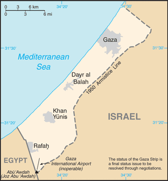
Gaza Strip:
Advertisement
GPS points near Dhahrat Umm `Amir
 Shaykh Shabani (0.5km)
Sheikh Shubani (0.5km)
Mukhayyam Nusayrat (1 km)
Nusayrat (2 km)
Nuseira (2 km)
Nuseirat (2 km)
Shaykh Rashid (2 km)
Sheikh Rashid (2 km)
Tall as Sanam (2 km)
Rashidah (3 km)
Rashida Station (3 km)
Rashiea (3 km)
Kear Darom (3 km)
Kefar Darom (3 km)
Maghazi (3 km)
Mukhayyam Shaykh al Maghazi (3 km)
Belar (3 km)
Shaykh Shabani (0.5km)
Sheikh Shubani (0.5km)
Mukhayyam Nusayrat (1 km)
Nusayrat (2 km)
Nuseira (2 km)
Nuseirat (2 km)
Shaykh Rashid (2 km)
Sheikh Rashid (2 km)
Tall as Sanam (2 km)
Rashidah (3 km)
Rashida Station (3 km)
Rashiea (3 km)
Kear Darom (3 km)
Kefar Darom (3 km)
Maghazi (3 km)
Mukhayyam Shaykh al Maghazi (3 km)
Belar (3 km)
GPS points from Gaza Strip
|