41°19'60" N
43°55'0" E
~2,613m asl
02:24 (GET - UTC/GMT+4)
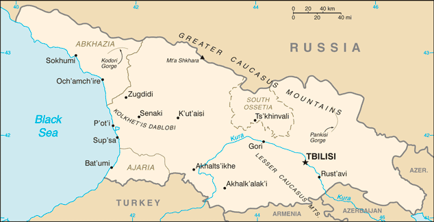
Kechutskiy Khrebet (Kechutskiy Khrebet) is a mountains (class T - Hypsographic) in Georgia (general), Georgia (Asia) with the region font code of Russia/ Central Asia. It is located at an elevation of 2,613 meters above sea level.
Kechutskiy Khrebet is also known as Dzhavakhetskiy Khrebet, Javakhet'is K'edi, Javakhet’is K’edi, Javakhk'i Lerrnashght'a, Javakhk’i Lerrnashght’a, Kechutskiy Khrebet, Kechutskiye Gory, Mokriya Ridge, Mokryje Gory, Mokryye Gory, ჯავახეთის ქედი.
Its coordinates are 41°19'60" N and 43°55'0" E in DMS (Degrees Minutes Seconds) or 41.3333 and 43.9167 (in decimal degrees). Its UTM position is ML07 and its Joint Operation Graphics reference is NK38-07.
Current local time is 02:24; the sun rises at 08:55 and sets at 21:02 local time (Asia/Tbilisi UTC/GMT+4). The standard time zone for Kechutskiy Khrebet is UTC/GMT+4
In 2024 DST starts on - and ends on -.
A Mountains is a mountain range or a group of mountains or high ridges.
|
Advertisements:
Advertisements:
|
Weather Kechutskiy Khrebet (Cloud cover, Temperature, Wind speed and Precipitation mm probab.)
Thu
Apr 18
11 °C min
12 °C max
9 km/h
Thu Jan 1
|
Fri
Apr 19
~4 l/m2 55%
4 °C min
16 °C max
12 km/h
Thu Jan 1
|
Sat
Apr 20
~6 l/m2 65%
4 °C min
12 °C max
18 km/h
Thu Jan 1
|
Sun
Apr 21
~5 l/m2 52%
3 °C min
13 °C max
13 km/h
Thu Jan 1
|
Mon
Apr 22
~6 l/m2 60%
4 °C min
12 °C max
13 km/h
Thu Jan 1
|
Tue
Apr 23
~2 l/m2 32%
0 °C min
13 °C max
10 km/h
Thu Jan 1
|
|
|
Javakhet'is K'edi (Georgia (general)) 7 day forecast
Map and Photos Kechutskiy Khrebet
--- There are no comments yet ---
Add a new comment:
|
Members area
Georgia (Tbilisi):
Advertisement
GPS points near Kechutskiy Khrebet
GPS points from Georgia (Tbilisi)
|
 Gora Agrikar (2 km)