English   Română   Español   Français   Deutsch  

getamap.net

Africa

Oceania

Asia

North America

Europe

South America

Antarctica


South Mayreau Channel

/ Grenadines

12°37'0" N
61°24'0" W
~0m asl
11:41 (AST - UTC/GMT--4)

South Mayreau Channel (South Mayreau Channel) is a marine channel (class H - Hydrographic) in Grenadines, Saint Vincent And The Grenadines (North America) with the region font code of Americas/Western Europe...

Its coordinates are 12°37'0" N and 61°24'0" W in DMS (Degrees Minutes Seconds) or 12.6167 and -61.4 (in decimal degrees). Its UTM position is PU79 and its Joint Operation Graphics reference is ND20-16.

Current local time is 11:41; the sun rises at 08:55 and sets at 21:02 local time (America/St_Vincent UTC/GMT-4). The standard time zone for South Mayreau Channel is UTC/GMT-4
In 2024 DST starts on - and ends on -.

A Marine channel is that part of a body of water deep enough for navigation through an area otherwise not suitable.


Country
 Advertisements:


 Advertisements:


Weather South Mayreau Channel (Cloud cover, Temperature, Wind speed and Precipitation mm probab.)

Fri


Apr 19
Clound 0-10-10-80
~1 l/m2 22%
 
27 °C min
28 °C max
18 km/h
Thu Jan 1

Sat


Apr 20
Clound 40-0-0-80 Lightning
~18 l/m2 64%
 
26 °C min
28 °C max
25 km/h
Thu Jan 1

Sun


Apr 21
Clound 20-10-0-60 Lightning
~4 l/m2 36%
 
27 °C min
29 °C max
28 km/h
Thu Jan 1

Mon


Apr 22
Clound 20-20-10-30 Lightning
~0.3 l/m2 14%
 
27 °C min
29 °C max
32 km/h
Thu Jan 1

Tue


Apr 23
Clound 30-50-0-20 Lightning
~1 l/m2 22%
 
27 °C min
28 °C max
33 km/h
Thu Jan 1

Wed


Apr 24
Clound 10-10-0-20
~1 l/m2 24%
 
27 °C min
28 °C max
30 km/h
Thu Jan 1

Weather Graph

South Mayreau Channel (Grenadines) 7 day forecast
 

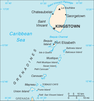
Map and Photos South Mayreau Channel


Comments

--- There are no comments yet ---


Add a new comment:


You have to log in to add a comment!


Members area


Register

Forgot password?

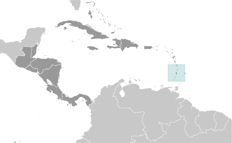
Saint Vincent And The Grenadines (Kingstown):

Advertisement


GPS points near South Mayreau Channel

square Saline Bay (1 km)

square Old Wall (2 km)

square Upper Bay (2 km)

square Red Island (2 km)

square Red Islet (2 km)

square Richmond Bay (2 km)

square Palm Island (3 km)

square Prune Island (3 km)

square Prune Island (3 km)

square Prune Islet (3 km)

square Sand Cay (4 km)

square Union Island (4 km)

square Mayaro Island (4 km)

square Mayero Island (4 km)

square Mayreau (4 km)

square Clifton (4 km)

square Cliftons (4 km)


GPS points from Saint Vincent And The Grenadines (Kingstown)

square L'ansecoy Bay Grenadines

square Point Peter Parish Of Saint George

square Milligan's Cay Parish Of Saint George

square Edinboro Bay Parish Of Saint Andrew

square Ocar Point Saint Vincent And The Grenadines (general)

square Point Bay Saint Vincent And The Grenadines (general)

square Petit Mustique Grenadines

square Rabbit Island Grenadines


viewweather.com sv.ViewWeather.com
fr.ViewWeather.com
da.ViewWeather.com
de.ViewWeather.com
es.ViewWeather.com
www.carpati.org
www.searchromania.net
Deblocari usi
es.getamap.org
fr.getamap.org
de.getamap.org
nl.getamap.org
da.getamap.org
www.getamap.org
Links
Terms of use
Privacy policy

# 0.0637 sec 

contact AT getamap.net

© 2006 - 2024  https://www.getamap.net/