|
|
|
Lopa Ma Lototanga
Weather Lopa Ma Lototanga (Cloud cover, Temperature, Wind speed and Precipitation mm probab.)
Map and Photos Lopa Ma Lototanga
Comments
Add a new comment: |
Members area
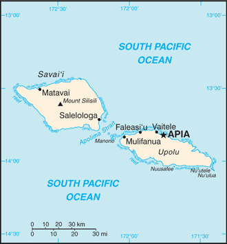
Samoa (Apia):
Advertisement
GPS points near Lopa Ma Lototanga
 Etemuli (3 km)
Lepa (4 km)
Lotofaga (4 km)
Lotofanga (4 km)
Vavau (4 km)
Va`a-o-Fonoti (5 km)
Aufaga (5 km)
Letaupe (5 km)
Matatufu (5 km)
Lepa (5 km)
Salani (5 km)
Siuniu (5 km)
Lona Cataract (5 km)
Malata Berg (5 km)
Malata Mountain (5 km)
Tavalagi Pass (6 km)
Saleapaga (6 km)
Etemuli (3 km)
Lepa (4 km)
Lotofaga (4 km)
Lotofanga (4 km)
Vavau (4 km)
Va`a-o-Fonoti (5 km)
Aufaga (5 km)
Letaupe (5 km)
Matatufu (5 km)
Lepa (5 km)
Salani (5 km)
Siuniu (5 km)
Lona Cataract (5 km)
Malata Berg (5 km)
Malata Mountain (5 km)
Tavalagi Pass (6 km)
Saleapaga (6 km)
GPS points from Samoa (Apia)
|