|
|
|
Mulivai Tane
Weather Mulivai Tane (Cloud cover, Temperature, Wind speed and Precipitation mm probab.)
Map and Photos Mulivai Tane
Comments
Add a new comment: |
Members area
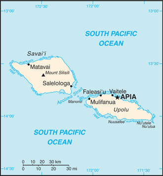
Samoa (Apia):
Advertisement
GPS points near Mulivai Tane
 Lauli`i River (1 km)
Leusoalii (1 km)
Namo (2 km)
Casino Island (3 km)
Casino Islet (3 km)
Lauli`i (3 km)
Letogo River (5 km)
Letongo River (5 km)
Rosa Rock (5 km)
Solosolo (5 km)
Albatross Island (5 km)
Albatross Islet (5 km)
Leading Peak (5 km)
Letogo (5 km)
Letongo (5 km)
Saluafata Bank (5 km)
Vailele Bay (5 km)
Lauli`i River (1 km)
Leusoalii (1 km)
Namo (2 km)
Casino Island (3 km)
Casino Islet (3 km)
Lauli`i (3 km)
Letogo River (5 km)
Letongo River (5 km)
Rosa Rock (5 km)
Solosolo (5 km)
Albatross Island (5 km)
Albatross Islet (5 km)
Leading Peak (5 km)
Letogo (5 km)
Letongo (5 km)
Saluafata Bank (5 km)
Vailele Bay (5 km)
GPS points from Samoa (Apia)
|