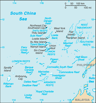
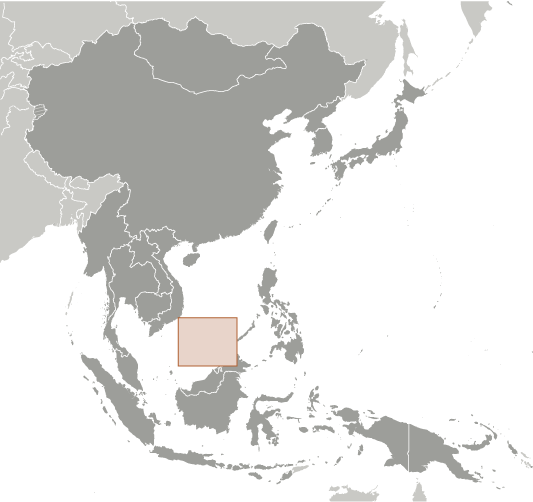
Quan Ðao Trường Sa
10°0'0" N
114°0'0" E
( - UTC/GMT+)
Quan Dao Truong Sa (Quan Ðao Trường Sa) is a islands (class T - Hypsographic) in (disputed), Spratly Islands [ Undetermined ] (Asia) with the region font code of Vietnam.
Its coordinates are 10°0'0" N and 114°0'0" E in DMS (Degrees Minutes Seconds) or 10 and 114 (in decimal degrees). Its UTM position is JS70 and its Joint Operation Graphics reference is NC50-05.
Current local time is ; the sun rises at 08:54 and sets at 21:01 local time ( UTC/GMT+). The standard time zone for Quan Dao Truong Sa is UTC/GMT+
In 2024 DST starts on - and ends on -.
A Islands is tracts of land, smaller than a continent, surrounded by water at high water.
|
Advertisements:
Advertisements:
|
Weather Quan Ðao Trường Sa (Cloud cover, Temperature, Wind speed and Precipitation mm probab.)
Tue
Apr 23
29 °C min
30 °C max
16 km/h
Thu Jan 1
|
Wed
Apr 24
29 °C min
31 °C max
15 km/h
Thu Jan 1
|
Thu
Apr 25
~2 l/m2 31%
29 °C min
30 °C max
20 km/h
Thu Jan 1
|
Fri
Apr 26
29 °C min
30 °C max
23 km/h
Thu Jan 1
|
Sat
Apr 27
29 °C min
31 °C max
21 km/h
Thu Jan 1
|
Sun
Apr 28
~1 l/m2 35%
29 °C min
31 °C max
21 km/h
Thu Jan 1
|
|
|
Map and Photos Quan Dao Truong Sa
--- There are no comments yet ---
Add a new comment:
|
Members area
Spratly Islands [ Undetermined ]:
Advertisement
GPS points near Quan Ðao Trường Sa
GPS points from Spratly Islands [ Undetermined ]
|