21°10'0" N
71°0'0" W
~0m asl
20:20 (EDT - UTC/GMT--4)
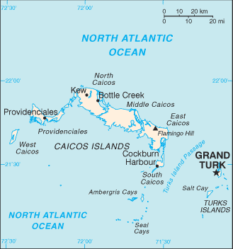
Passe du Mouchoir Carre (Passe du Mouchoir Carre) is a channel (class H - Hydrographic) in Turks and Caicos Islands (general), Turks And Caicos Islands [ United Kingdom ] (North America) with the region font code of Americas/Western Europe...
Passe du Mouchoir Carre is also known as Mouchoir Carre Passage, Mouchoir Carré Passage, Mouchoir Passage, Passe du Mouchoir Carre, Passe du Mouchoir carre.
Its coordinates are 21°10'0" N and 71°0'0" W in DMS (Degrees Minutes Seconds) or 21.1667 and -71 (in decimal degrees). Its UTM position is BD94 and its Joint Operation Graphics reference is NF19-07.
Current local time is 20:20; the sun rises at 07:55 and sets at 20:02 local time (America/Grand_Turk UTC/GMT-4). The standard time zone for Passe du Mouchoir Carre is UTC/GMT-5, but since Daylight Saving Time (DST) is in effect the current time zone is UTC/GMT-4.
In 2024 DST starts on 10 Mar 2024 and ends on 3 Nov 2024.
A Channel is the deepest part of a stream, bay, lagoon, or strait, through which the main current flows.
|
Advertisements:
Advertisements:
|
Weather Passe du Mouchoir Carre (Cloud cover, Temperature, Wind speed and Precipitation mm probab.)
Fri
Apr 19
~1 l/m2 18%
24 °C min
25 °C max
29 km/h
Thu Jan 1
|
Sat
Apr 20
24 °C min
26 °C max
28 km/h
Thu Jan 1
|
Sun
Apr 21
~2 l/m2 25%
24 °C min
26 °C max
31 km/h
Thu Jan 1
|
Mon
Apr 22
~0.3 l/m2 13%
25 °C min
27 °C max
28 km/h
Thu Jan 1
|
Tue
Apr 23
~1 l/m2 15%
25 °C min
27 °C max
24 km/h
Thu Jan 1
|
Wed
Apr 24
25 °C min
27 °C max
21 km/h
Thu Jan 1
|
|
|
Mouchoir Passage (Turks and Caicos Islands (general)) 7 day forecast
Map and Photos Passe du Mouchoir Carre
--- There are no comments yet ---
Add a new comment:
|
Advertisement
Members area
Turks And Caicos Islands [ United Kingdom ] (Overseas Territory):
GPS points from Turks And Caicos Islands [ United Kingdom ] (Overseas Territory)
 Long Bay Turks And Caicos Islands (general)
Caicos Turks And Caicos Islands (general)
|