English   Română   Español   Français   Deutsch  

getamap.net

Africa

Oceania

Asia

North America

Europe

South America

Antarctica


21°28'60" N
71°7'60" W
~1m asl
20:58 (EDT - UTC/GMT--4)

North Creek (North Creek) is a salt pond (class H - Hydrographic) in Turks and Caicos Islands (general), Turks And Caicos Islands [ United Kingdom ] (North America) with the region font code of Americas/Western Europe. It is located at an elevation of 1 meters above sea level.

Its coordinates are 21°28'60" N and 71°7'60" W in DMS (Degrees Minutes Seconds) or 21.4833 and -71.1333 (in decimal degrees). Its UTM position is BD77 and its Joint Operation Graphics reference is NF19-09.

Current local time is 20:58; the sun rises at 07:55 and sets at 20:02 local time (America/Grand_Turk UTC/GMT-4). The standard time zone for North Creek is UTC/GMT-5, but since Daylight Saving Time (DST) is in effect the current time zone is UTC/GMT-4.
In 2024 DST starts on 10 Mar 2024 and ends on 3 Nov 2024.

A Salt pond is a small standing body of salt water often in a marsh or swamp, usually along a seacoast.


Country
 Advertisements:


 Advertisements:


Weather North Creek (Cloud cover, Temperature, Wind speed and Precipitation mm probab.)

Thu


Apr 18
Clound 0-10-0-0
 
24 °C min
26 °C max
31 km/h
Thu Jan 1

Fri


Apr 19
Clound 20-10-0-50
 
24 °C min
25 °C max
28 km/h
Thu Jan 1

Sat


Apr 20
Clound 0-20-0-0
 
24 °C min
26 °C max
28 km/h
Thu Jan 1

Sun


Apr 21
Clound 20-30-0-0
~2 l/m2 29%
 
24 °C min
26 °C max
33 km/h
Thu Jan 1

Mon


Apr 22
Clound 10-10-0-0
 
25 °C min
26 °C max
32 km/h
Thu Jan 1

Tue


Apr 23
Clound 0-10-0-0
 
25 °C min
27 °C max
23 km/h
Thu Jan 1

Weather Graph

North Creek (Turks and Caicos Islands (general)) 7 day forecast
 

Map and Photos North Creek


Comments

--- There are no comments yet ---


Add a new comment:


You have to log in to add a comment!


Members area


Register

Forgot password?

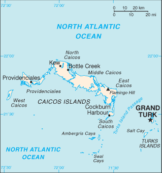
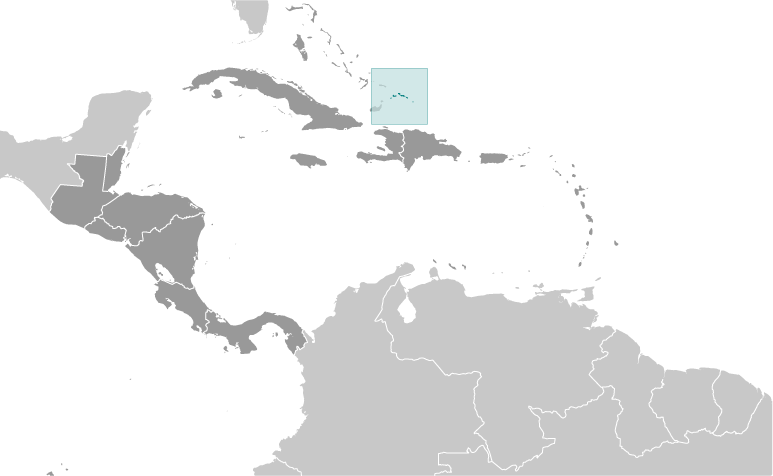
Turks And Caicos Islands [ United Kingdom ] (Overseas Territory):

Advertisement


GPS points near North Creek

square Grand Turk (1 km)


square Cockburn Town (1 km)

square Corry Hill (1 km)

square Grand Turk (1 km)

square The Island (1 km)


square Town Pond (1 km)

square Town Salinas (1 km)

square West Road (1 km)

square Back Salina (3 km)

square Red Salina (3 km)

square Gun Hill (5 km)

square Gibb Cay (6 km)

square Gibb's Cay (6 km)


GPS points from Turks And Caicos Islands [ United Kingdom ] (Overseas Territory)

square Lorimers Turks And Caicos Islands (general)

square Grassy Creek Turks And Caicos Islands (general)

square Grande Caique Turks And Caicos Islands (general)

square Caique Du Nord Turks And Caicos Islands (general)

square Mouchoir Carre Passage Turks And Caicos Islands (general)

square South Caicos Turks And Caicos Islands (general)

square The Bight Turks And Caicos Islands (general)

square Kew Turks And Caicos Islands (general)


viewweather.com sv.ViewWeather.com
fr.ViewWeather.com
da.ViewWeather.com
de.ViewWeather.com
es.ViewWeather.com
www.carpati.org
www.searchromania.net
Deblocari usi
es.getamap.org
fr.getamap.org
de.getamap.org
nl.getamap.org
da.getamap.org
www.getamap.org
Links
Terms of use
Privacy policy

# 0.0640 sec 

contact AT getamap.net

© 2006 - 2024  https://www.getamap.net/