English   Română   Español   Français   Deutsch  

getamap.net

Africa

Oceania

Asia

North America

Europe

South America

Antarctica


13°15'0" S
176°10'59" W
~66m asl
17:53 (WFT - UTC/GMT+12)

Fakauita (Fakauita) is a populated place (class P - Populated Place) in Wallis and Futuna (general), Wallis And Futuna [ France ] (Oceania) with the region font code of Americas/Western Europe. It is located at an elevation of 66 meters above sea level and its population amounts to 901.

Its coordinates are 13°15'0" S and 176°10'59" W in DMS (Degrees Minutes Seconds) or -13.25 and -176.183 (in decimal degrees). Its UTM position is EF83 and its Joint Operation Graphics reference is SD01-07.

Current local time is 17:53; the sun rises at 08:55 and sets at 21:02 local time (Pacific/Wallis UTC/GMT+12). The standard time zone for Fakauita is UTC/GMT+12
In 2024 DST starts on - and ends on -.

A Populated place is a city, town, village, or other agglomeration of buildings where people live and work.


Country
 Advertisements:


 Advertisements:


Weather Fakauita (Cloud cover, Temperature, Wind speed and Precipitation mm probab.)

Tue


Apr 16
Clound 40-10-0-90
~5 l/m2 42%
 
29 °C min
30 °C max
27 km/h
Thu Jan 1

Wed


Apr 17
Clound 40-10-30-90 Lightning
~17 l/m2 60%
 
28 °C min
30 °C max
32 km/h
Thu Jan 1

Thu


Apr 18
Clound 50-10-30-100 Lightning
~34 l/m2 81%
 
28 °C min
30 °C max
29 km/h
Thu Jan 1

Fri


Apr 19
Clound 20-10-0-80
~7 l/m2 42%
 
28 °C min
30 °C max
21 km/h
Thu Jan 1

Sat


Apr 20
Clound 40-20-10-70
~10 l/m2 41%
 
28 °C min
30 °C max
27 km/h
Thu Jan 1

Sun


Apr 21
Clound 30-10-0-10
~7 l/m2 37%
 
28 °C min
30 °C max
27 km/h
Thu Jan 1

Weather Graph

Fakauita (Wallis and Futuna (general)) 7 day forecast
 

Map and Photos Fakauita


Comments

--- There are no comments yet ---


Add a new comment:


You have to log in to add a comment!


Members area


Register

Forgot password?

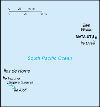
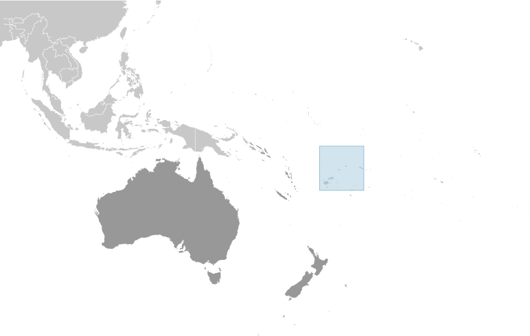
Wallis And Futuna [ France ] (Overseas Territory):

Advertisement


GPS points near Fakauita

square Fakauita (0.5km)

square Utuloa (1 km)

square Mont Lula (2 km)

square Mont Lulu (2 km)


square Lulu Hill (2 km)


square West Bay (3 km)

square Mont Hologa (3 km)

square Mont Afala (4 km)

square Mont Loka (4 km)

square Loka Hill (4 km)

square Mount Loko (4 km)

square Mont Lulu Luo (4 km)

square Alele (4 km)


GPS points from Wallis And Futuna [ France ] (Overseas Territory)

square Bayonnaise Seamount Wallis And Futuna (general)

square Pointe Matala Wallis And Futuna (general)

square Passe Avatolu Wallis And Futuna (general)

square Tepoko Point Wallis And Futuna (general)

square Pointe Tepako Wallis And Futuna (general)

square Teesi Wallis And Futuna (general)

square Lulu Hill Wallis And Futuna (general)

square Sommet Singavi Wallis And Futuna (general)


viewweather.com sv.ViewWeather.com
fr.ViewWeather.com
da.ViewWeather.com
de.ViewWeather.com
es.ViewWeather.com
www.carpati.org
www.searchromania.net
Deblocari usi
es.getamap.org
fr.getamap.org
de.getamap.org
nl.getamap.org
da.getamap.org
www.getamap.org
Links
Terms of use
Privacy policy

# 0.0629 sec 

contact AT getamap.net

© 2006 - 2024  https://www.getamap.net/