English   Română   Español   Français   Deutsch  

getamap.net

Africa

Oceania

Asia

North America

Europe

South America

Antarctica


Mua Anchorage

(Chenal Sain) / Wallis and Futuna (general)

14°19'60" S
178°3'0" W
~5m asl
14:32 (WFT - UTC/GMT+12)

Mua Anchorage (Mua Anchorage) is a anchorage (class H - Hydrographic) in Wallis and Futuna (general), Wallis And Futuna [ France ] (Oceania) with the region font code of Americas/Western Europe. It is located at an elevation of 5 meters above sea level.

Its coordinates are 14°19'60" S and 178°3'0" W in DMS (Degrees Minutes Seconds) or -14.3333 and -178.05 (in decimal degrees). Its UTM position is CE81 and its Joint Operation Graphics reference is SD01-10.

Current local time is 14:32; the sun rises at 08:54 and sets at 21:01 local time (Pacific/Wallis UTC/GMT+12). The standard time zone for Mua Anchorage is UTC/GMT+12
In 2024 DST starts on - and ends on -.

A Anchorage is an area where vessels may anchor.


Country
 Advertisements:


 Advertisements:


Weather Mua Anchorage (Cloud cover, Temperature, Wind speed and Precipitation mm probab.)

Thu


Apr 25
Clound 0-10-0-50
 
28 °C min
30 °C max
12 km/h
Thu Jan 1

Fri


Apr 26
Clound 20-10-0-50 Lightning
~5 l/m2 43%
 
28 °C min
30 °C max
17 km/h
Thu Jan 1

Sat


Apr 27
Clound 30-10-0-10 Lightning
~5 l/m2 43%
 
28 °C min
30 °C max
25 km/h
Thu Jan 1

Sun


Apr 28
Clound 40-20-0-10
~6 l/m2 36%
 
29 °C min
30 °C max
32 km/h
Thu Jan 1

Mon


Apr 29
Clound 40-10-0-20
~5 l/m2 44%
 
28 °C min
30 °C max
30 km/h
Thu Jan 1

Tue


Apr 30
Clound 20-10-0-30
~1 l/m2 24%
 
28 °C min
30 °C max
24 km/h
Thu Jan 1

Weather Graph

Chenal Sain (Wallis and Futuna (general)) 7 day forecast
 

Map and Photos Mua Anchorage


Comments

--- There are no comments yet ---


Add a new comment:


You have to log in to add a comment!


Members area


Register

Forgot password?

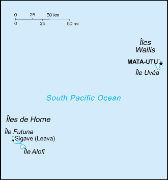
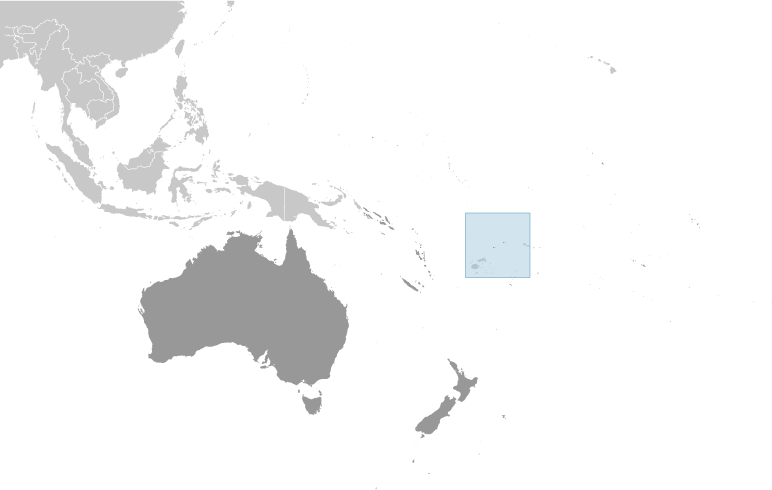
Wallis And Futuna [ France ] (Overseas Territory):

Advertisement


GPS points near Mua Anchorage


square Alofitai (1 km)

square Mua (1 km)


square Vele (2 km)

square Pointe Vele (2 km)

square Alofa (2 km)

square Ile Alofi (2 km)


square Mont Kolofau (2 km)

square Green Point (3 km)

square Pointe Verte (3 km)

square Iles Futuna (4 km)


square Iles de Hoorn (4 km)


GPS points from Wallis And Futuna [ France ] (Overseas Territory)

square Mont Lausikula Wallis And Futuna (general)

square Sommet De Schouwen Wallis And Futuna (general)

square Isabella Bank Wallis And Futuna (general)

square Feletoa Wallis And Futuna (general)

square Mua Wallis And Futuna (general)

square Territoire Des Iles Wallis Et Futuna Wallis And Futuna (general)

square Sigave Wallis And Futuna (general)

square Lac Kikila Wallis And Futuna (general)


viewweather.com sv.ViewWeather.com
fr.ViewWeather.com
da.ViewWeather.com
de.ViewWeather.com
es.ViewWeather.com
www.carpati.org
www.searchromania.net
Deblocari usi
es.getamap.org
fr.getamap.org
de.getamap.org
nl.getamap.org
da.getamap.org
www.getamap.org
Links
Terms of use
Privacy policy

# 0.0704 sec 

contact AT getamap.net

© 2006 - 2024  https://www.getamap.net/