|

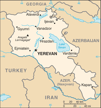
Administrative divisions (GPS Maps)
Geography
People and Society
Government
Economy
Communications
Transportation
Military |
 |
 Armenia prides itself on being the first nation to formally adopt Christianity (early 4th century). Despite periods of autonomy, over the centuries Armenia came under the sway of various empires including the Roman, Byzantine, Arab, Persian, and Ottoman. During World War I in the western portion of Armenia, Ottoman Turkey instituted a policy of forced resettlement coupled with other harsh practices that resulted in at least 1 million Armenian deaths. The eastern area of Armenia was ceded by the Ottomans to Russia in 1828; this portion declared its independence in 1918, but was conquered by the Soviet Red Army in 1920. Armenian leaders remain preoccupied by the long conflict with Azerbaijan over Nagorno-Karabakh, a primarily Armenian-populated region, assigned to Soviet Azerbaijan in the 1920s by Moscow. Armenia and Azerbaijan began fighting over the area in 1988; the struggle escalated after both countries attained independence from the Soviet Union in 1991. By May 1994, when a cease-fire took hold, ethnic Armenian forces held not only Nagorno-Karabakh but also a significant portion of Azerbaijan proper. The economies of both sides have been hurt by their inability to make substantial progress toward a peaceful resolution. Turkey closed the common border with Armenia in 1994 in support of Azerbaijan in its conflict with Armenia over control of Nagorno-Karabakh and surrounding areas, further hampering Armenian economic growth. In 2009, senior Armenian leaders began pursuing rapprochement with Turkey, aiming to secure an opening of the border. Armenia prides itself on being the first nation to formally adopt Christianity (early 4th century). Despite periods of autonomy, over the centuries Armenia came under the sway of various empires including the Roman, Byzantine, Arab, Persian, and Ottoman. During World War I in the western portion of Armenia, Ottoman Turkey instituted a policy of forced resettlement coupled with other harsh practices that resulted in at least 1 million Armenian deaths. The eastern area of Armenia was ceded by the Ottomans to Russia in 1828; this portion declared its independence in 1918, but was conquered by the Soviet Red Army in 1920. Armenian leaders remain preoccupied by the long conflict with Azerbaijan over Nagorno-Karabakh, a primarily Armenian-populated region, assigned to Soviet Azerbaijan in the 1920s by Moscow. Armenia and Azerbaijan began fighting over the area in 1988; the struggle escalated after both countries attained independence from the Soviet Union in 1991. By May 1994, when a cease-fire took hold, ethnic Armenian forces held not only Nagorno-Karabakh but also a significant portion of Azerbaijan proper. The economies of both sides have been hurt by their inability to make substantial progress toward a peaceful resolution. Turkey closed the common border with Armenia in 1994 in support of Azerbaijan in its conflict with Armenia over control of Nagorno-Karabakh and surrounding areas, further hampering Armenian economic growth. In 2009, senior Armenian leaders began pursuing rapprochement with Turkey, aiming to secure an opening of the border. |
|
Advertisements
|
Advertisements
|
Airports World Ranking: 155
11 (2012)
Airports - with paved runways
Total 10
Over 3,047 m 2
2,438 to 3,047 m 2
1,524 to 2,437 m 4
914 to 1,523 m 2 (2012)
Airports - with unpaved runways
Total 1
914 to 1,523 m 1 (2012)
Pipelines
Gas 2,233 km (2010)
Railways World Ranking: 96
Total 869 km Broad gauge 869 km 1.520-m gauge (818 km electrified) Note Some lines are out of service (2009)
Roadways World Ranking: 139
Total 8,888 km Paved 7,079 km (includes 1,561 km of expressways) Unpaved 1,809 km (2008)
--- There are no comments yet ---
Add a new comment:
|
Advertisement
Members area
Armenia (Yerevan):
GPS points from Armenia (Yerevan)
|