|
|
|
Advertisements:
GeographyLocation
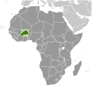
Western Africa, north of Ghana
Geographic coordinates
13 00 N, 2 00 W
Map references
Africa
Area World Ranking: 75
Total 274,200 sq km
Land 273,800 sq km Water 400 sq km Area - comparative
Slightly larger than Colorado
Land boundaries
Total 3,193 km
Border countries Benin 306 km, Cote d'Ivoire 584 km, Ghana 549 km, Mali 1,000 km, Niger 628 km, Togo 126 km Coastline
0 km (landlocked)
Maritime claims
None (landlocked)
Climate
Tropical; warm, dry winters; hot, wet summers Terrain
Mostly flat to dissected, undulating plains; hills in west and southeast Elevation extremes
Lowest point
Mouhoun (Black Volta) River 200 m Highest point Tena Kourou 749 mNatural resources
Manganese, limestone, marble; small deposits of gold, phosphates, pumice, salt Land use
Arable land 17.66%
Permanent crops 0.22% Other 82.12% (2005) Irrigated land
300 sq km (2003)
Total renewable water resources
17.5 cu km (2001)
Freshwater withdrawal (domestic/industrial/agricultural)
Total 0.8 cu km/yr (13%/1%/86%)
Per capita 60 cu m/yr (2000) Natural hazards
Recurring droughts
Environment - current issues
Recent droughts and desertification severely affecting agricultural activities, population distribution, and the economy; overgrazing; soil degradation; deforestation Environment - international agreements
Party to
Biodiversity, Climate Change, Climate Change-Kyoto Protocol, Desertification, Endangered Species, Hazardous Wastes, Law of the Sea, Marine Life Conservation, Ozone Layer Protection, Wetlands Signed, but not ratified None of the selected agreements Geography - note
Landlocked savanna cut by the three principal rivers of the Black, Red, and White Voltas
Comments
Add a new comment: |
Advertisement
Members area
Burkina Faso (Ouagadougou):
 
GPS points from Burkina Faso (Ouagadougou)
|
||||||||

 Burkina Faso (formerly Upper Volta) achieved independence from France in 1960. Repeated military coups during the 1970s and 1980s were followed by multiparty elections in the early 1990s. Current President Blaise COMPAORE came to power in a 1987 military coup and has won every election since then. Burkina Faso's high population density and limited natural resources result in poor economic prospects for the majority of its citizens.