|
|
|
Advertisements:
GeographyLocation
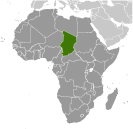
Central Africa, south of Libya
Geographic coordinates
15 00 N, 19 00 E
Map references
Africa
Area World Ranking: 21
Total 1.284 million sq km
Land 1,259,200 sq km Water 24,800 sq km Area - comparative
Slightly more than three times the size of California Land boundaries
Total 5,968 km
Border countries Cameroon 1,094 km, Central African Republic 1,197 km, Libya 1,055 km, Niger 1,175 km, Nigeria 87 km, Sudan 1,360 km Coastline
0 km (landlocked)
Maritime claims
None (landlocked)
Climate
Tropical in south, desert in north Terrain
Broad, arid plains in center, desert in north, mountains in northwest, lowlands in south Elevation extremes
Lowest point Djourab 160 m
Highest point Emi Koussi 3,415 m Natural resources
Petroleum, uranium, natron, kaolin, fish (Lake Chad), gold, limestone, sand and gravel, salt Land use
Arable land 2.8%
Permanent crops 0.02% Other 97.18% (2005) Irrigated land
300 sq km (2003)
Total renewable water resources
43 cu km (1987)
Freshwater withdrawal (domestic/industrial/agricultural)
Total 0.23 cu km/yr (17%/0%/83%)
Per capita 24 cu m/yr (2000) Natural hazards
Hot, dry, dusty harmattan winds occur in north; periodic droughts; locust plagues Environment - current issues
Inadequate supplies of potable water; improper waste disposal in rural areas contributes to soil and water pollution; desertification Environment - international agreements
Party to
Biodiversity, Climate Change, Desertification, Endangered Species, Hazardous Wastes, Ozone Layer Protection, Wetlands Signed, but not ratified Law of the Sea, Marine DumpingGeography - note
Landlocked; Lake Chad is the most significant water body in the Sahel
Comments
Add a new comment: |
Advertisement
Members area
Chad (N'djamena):
 
GPS points from Chad (N'djamena)
|
||||||||

 Chad, part of France's African holdings until 1960, endured three decades of civil warfare as well as invasions by Libya before a semblance of peace was finally restored in 1990. The government eventually drafted a democratic constitution and held flawed presidential elections in 1996 and 2001. In 1998, a rebellion broke out in northern Chad, which has sporadically flared up despite several peace agreements between the government and the rebels. In 2005, new rebel groups emerged in western Sudan and made probing attacks into eastern Chad despite signing peace agreements in December 2006 and October 2007. In June 2005, President Idriss DEBY held a referendum successfully removing constitutional term limits and won another controversial election in 2006. Sporadic rebel campaigns continued throughout 2006 and 2007. The capital experienced a significant rebel threat in early 2008, but has had no significant rebel threats since then, in part due to Chad's 2010 rapprochement with Sudan, which previously used Chadian rebels as proxies. DEBY in 2011 was reelected to his fourth term in an election that international observers described as proceeding without incident. Power remains in the hands of an ethnic minority.