|
|
Advertisements:
TransportationAirports World Ranking: 8
862 (2012)
Airports - with paved runways
Total 121
Over 3,047 m 2 2,438 to 3,047 m 7 1,524 to 2,437 m 41 914 to 1,523 m 55 Under 914 m 16 (2012) Airports - with unpaved runways
Total 741
Over 3,047 m 1 1,524 to 2,437 m 25 914 to 1,523 m 178 Under 914 m 537 (2012) Heliports
2 (2012)
Pipelines
Gas 4,801 km; oil 6,334 km; refined products 3,309 km (2010) Railways World Ranking: 95
Total 874 km
Standard gauge 150 km 1.435-m gauge Narrow gauge 498 km 0.950-m gauge; 226 km 0.914-m gauge (2008) Roadways World Ranking: 34
Total 141,374 km (2010)
Waterways World Ranking: 5
24,725 km (18,300 km navigable; the most important waterway, the River Magdalena, of which 1,488 km is navigable, is dredged regularly to ensure the safe passage of cargo vessels and container barges) (2012) Merchant marine World Ranking: 105
Total 12
By type Cargo 9, chemical tanker 1, petroleum tanker 2 Registered in other countries 4 (Antigua and Barbuda 1, Panama 2, Portugal 1) (2010) Ports and terminals
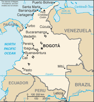
Barranquilla, Buenaventura, Cartagena, Puerto Bolivar, Santa Marta, Turbo Oil terminals Covenas offshore terminal
Comments
Add a new comment: |
Advertisement
Members area
Colombia (Bogota):
 
GPS points from Colombia (Bogota)
|
||||||||

 Colombia was one of the three countries that emerged from the collapse of Gran Colombia in 1830 (the others are Ecuador and Venezuela). A four-decade long conflict between government forces and anti-government insurgent groups, principally the Revolutionary Armed Forces of Colombia (FARC) heavily funded by the drug trade, escalated during the 1990s. The insurgents lack the military or popular support necessary to overthrow the government, and violence has been decreasing since about 2002. However, insurgents continue attacks against civilians and large areas of the countryside are under guerrilla influence or are contested by security forces. More than 31,000 former paramilitaries had demobilized by the end of 2006 and the United Self Defense Forces of Colombia (AUC) as a formal organization had ceased to function. In the wake of the paramilitary demobilization, emerging criminal groups arose, whose members include some former paramilitaries. The Colombian Government has stepped up efforts to reassert government control throughout the country, and now has a presence in every one of its administrative departments. However, neighboring countries worry about the violence spilling over their borders. In January 2011, Colombia assumed a nonpermanent seat on the UN Security Council for the 2011-12 term.