|
|
|
Advertisements:
GeographyLocation
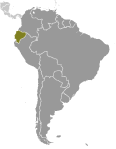
Western South America, bordering the Pacific Ocean at the Equator, between Colombia and Peru Geographic coordinates
2 00 S, 77 30 W
Map references
South America
Area World Ranking: 74
Total 283,561 sq km
Land 276,841 sq km Water 6,720 sq km Note Includes Galapagos Islands Area - comparative
Slightly smaller than Nevada
Land boundaries
Total 2,010 km
Border countries Colombia 590 km, Peru 1,420 km Coastline
2,237 km
Maritime claims
Territorial sea 200 nm
Continental shelf 100 nm from 2,500-m isobath Climate
Tropical along coast, becoming cooler inland at higher elevations; tropical in Amazonian jungle lowlands Terrain
Coastal plain (costa), inter-Andean central highlands (sierra), and flat to rolling eastern jungle (oriente) Elevation extremes
Lowest point Pacific Ocean 0 m
Highest point Chimborazo 6,267 m Note Due to the fact that the earth is not a perfect sphere and has an equatorial bulge, the highest point on the planet furthest from its center is Mount Chimborazo not Mount Everest, which is merely the highest peak above sea-level Natural resources
Petroleum, fish, timber, hydropower Land use
Arable land 5.71%
Permanent crops 4.81% Other 89.48% (2005) Irrigated land
8,650 sq km (2003)
Total renewable water resources
432 cu km (2000)
Freshwater withdrawal (domestic/industrial/agricultural)
Total 16.98 cu km/yr (12%/5%/82%)
Per capita 1,283 cu m/yr (2000) Natural hazards
Frequent earthquakes; landslides; volcanic activity; floods; periodic droughts Volcanism Volcanic activity concentrated along the Andes Mountains; Sangay (elev. 5,230 m), which erupted in 2010, is mainland Ecuador's most active volcano; other historically active volcanoes in the Andes include Antisana, Cayambe, Chacana, Cotopaxi, Guagua Pichincha, Reventador, Sumaco, and Tungurahua; Fernandina (elev. 1,476 m), a shield volcano that last erupted in 2009, is the most active of the many Galapagos volcanoes; other historically active Galapagos volcanoes include Wolf, Sierra Negra, Cerro Azul, Pinta, Marchena, and Santiago Environment - current issues
Deforestation; soil erosion; desertification; water pollution; pollution from oil production wastes in ecologically sensitive areas of the Amazon Basin and Galapagos Islands Environment - international agreements
Party to
Antarctic-Environmental Protocol, Antarctic Treaty, Biodiversity, Climate Change, Climate Change-Kyoto Protocol, Desertification, Endangered Species, Hazardous Wastes, Ozone Layer Protection, Ship Pollution, Tropical Timber 83, Tropical Timber 94, Wetlands Signed, but not ratified None of the selected agreements Geography - note
Cotopaxi in Andes is highest active volcano in world
Comments
Add a new comment: |
Advertisement
Members area
Ecuador (Quito):
 
GPS points from Ecuador (Quito)
|
||||||||

 What is now Ecuador formed part of the northern Inca Empire until the Spanish conquest in 1533. Quito became a seat of Spanish colonial government in 1563 and part of the Viceroyalty of New Granada in 1717. The territories of the Viceroyalty - New Granada (Colombia), Venezuela, and Quito - gained their independence between 1819 and 1822 and formed a federation known as Gran Colombia. When Quito withdrew in 1830, the traditional name was changed in favor of the "Republic of the Equator." Between 1904 and 1942, Ecuador lost territories in a series of conflicts with its neighbors. A border war with Peru that flared in 1995 was resolved in 1999. Although Ecuador marked 30 years of civilian governance in 2004, the period was marred by political instability. Protests in Quito contributed to the mid-term ouster of three of Ecuador's last four democratically elected Presidents. In late 2008, voters approved a new constitution, Ecuador's 20th since gaining independence. General elections, under the new constitutional framework, were held in April 2009, and voters re-elected President Rafael CORREA.