|
|
Advertisements:
People And SocietyNationality
Noun Eritrean(s)
Adjective Eritrean Ethnic groups
Nine recognized ethnic groups: Tigrinya 55%, Tigre 30%, Saho 4%, Kunama 2%, Rashaida 2%, Bilen 2%, other (Afar, Beni Amir, Nera) 5% (2010 est.) Languages
Tigrinya (official), Arabic (official), English (official), Tigre, Kunama, Afar, other Cushitic languages Religions
Muslim, Coptic Christian, Roman Catholic, Protestant Population World Ranking: 107
6,086,495 (July 2012 est.)
Age structure
0-14 years
42.1% (male 1,256,384/female 1,244,569) 15-64 years 54.3% (male 1,580,535/female 1,641,911) 65 years and over 3.6% (male 96,627/female 119,458) (2011 est.) Median age
Total 18.9 years
Male 18.5 years Female 19.2 years (2012 est.) Population growth rate World Ranking: 32
2.418% (2012 est.)
Birth rate World Ranking: 36
32.1 births/1,000 population (2012 est.) Death rate World Ranking: 107
7.92 deaths/1,000 population (July 2012 est.) Net migration rate World Ranking: 85
0 migrant(s)/1,000 population (2012 est.) Urbanization
Urban population 22% of total population (2010)
Rate of urbanization 5.2% annual rate of change (2010-15 est.) Major cities - population
ASMARA (capital) 649,000 (2009) Sex ratio
At birth 1.03 male(s)/female
Under 15 years 1.01 male(s)/female 15-64 years 0.96 male(s)/female 65 years and over 0.79 male(s)/female Total population 0.98 male(s)/female (2011 est.) Maternal mortality rate World Ranking: 47
240 deaths/100,000 live births (2010) Infant mortality rate World Ranking: 61
Total 40.34 deaths/1,000 live births
Male 45.69 deaths/1,000 live births Female 34.82 deaths/1,000 live births (2012 est.) Life expectancy at birth World Ranking: 178
Total population 62.86 years
Male 60.73 years Female 65.06 years (2012 est.) Total fertility rate World Ranking: 34
4.37 children born/woman (2012 est.) Health expenditures World Ranking: 81
7% of GDP (2009)
Physicians density
0.05 physicians/1,000 population (2004) Hospital bed density
1.15 beds/1,000 population (2006) Hiv/aids - adult prevalence rate World Ranking: 55
0.8% (2009 est.)
Hiv/aids - people living with hiv/aids World Ranking: 72
25,000 (2009 est.)
Hiv/aids - deaths World Ranking: 55
1,700 (2009 est.)
Major infectious diseases
Degree of risk High
Food or waterborne diseases Bacterial diarrhea, hepatitis A, and typhoid fever Vectorborne disease Malaria (2009)Obesity - adult prevalence rate World Ranking: 63
3.3% (2004)
Children under the age of 5 years underweight World Ranking: 11
34.5% (2002)
Education expenditures World Ranking: 156
2% of GDP (2006)
Literacy
Definition
Age 15 and over can read and write Total population 67.8%Male 78.7% Female 57.5% (2010 est.) School life expectancy (primary to tertiary education)
Total 5 years
Male 6 years Female 4 years (2009)
Comments
Add a new comment: |
Advertisement
Members area
Eritrea (Asmara):
 
GPS points from Eritrea (Asmara)
|
||||||||

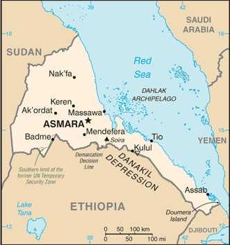
 The UN awarded Eritrea to Ethiopia in 1952 as part of a federation. Ethiopia's annexation of Eritrea as a province 10 years later sparked a 30-year struggle for independence that ended in 1991 with Eritrean rebels defeating governmental forces; independence was overwhelmingly approved in a 1993 referendum. A two-and-a-half-year border war with Ethiopia that erupted in 1998 ended under UN auspices in December 2000. Eritrea hosted a UN peacekeeping operation that monitored a 25 km-wide Temporary Security Zone (TSZ) on the border with Ethiopia. Eritrea's denial of fuel to the mission caused the UN to withdraw the mission and terminate its mandate 31 July 2008. An international commission, organized to resolve the border dispute, posted its findings in 2002. However, both parties have been unable to reach agreement on implementing the decision. On 30 November 2007, the Eritrea-Ethiopia Boundary Commission remotely demarcated the border by coordinates and dissolved itself, leaving Ethiopia still occupying several tracts of disputed territory, including the town of Badme. Eritrea accepted the EEBC's "virtual demarcation" decision and called on Ethiopia to remove its troops from the TSZ that it states is Eritrean territory. Ethiopia has not accepted the virtual demarcation decision. In 2009 the UN imposed sanctions on Eritrea after accusing it of backing anti-Ethiopian Islamist insurgents in Somalia.