|
|
Advertisements:
TransportationAirports World Ranking: 120
28 (2012)
Airports - with paved runways
Total 4
Over 3,047 m 1 1,524 to 2,437 m 1 914 to 1,523 m 2 (2012) Airports - with unpaved runways
Total 24
914 to 1,523 m 5 Under 914 m 19 (2012) Railways World Ranking: 108
Total 597 km
Narrow gauge 597 km 0.600-m gauge Note Belongs to the government-owned Fiji Sugar Corporation; used to haul sugarcane during the harvest season, which runs from May to December (2008) Roadways World Ranking: 162
Total 3,440 km
Paved 1,692 km Unpaved 1,748 km (2000) Waterways World Ranking: 98
203 km (122 km are navigable by motorized craft and 200-metric-ton barges) (2012) Merchant marine World Ranking: 108
Total 11
By type Passenger 4, passenger/cargo 4, refrigerated cargo 1, roll on/roll off 2 Foreign-owned 2 (Australia 2) (2010)Ports and terminals
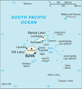
Lautoka, Levuka, Suva
Comments
Add a new comment: |
Advertisement
Members area
Fiji (Suva):
 
GPS points from Fiji (Suva)
|
||||||||

 Fiji became independent in 1970 after nearly a century as a British colony. Democratic rule was interrupted by two military coups in 1987 caused by concern over a government perceived as dominated by the Indian community (descendants of contract laborers brought to the islands by the British in the 19th century). The coups and a 1990 constitution that cemented native Melanesian control of Fiji led to heavy Indian emigration; the population loss resulted in economic difficulties, but ensured that Melanesians became the majority. A new constitution enacted in 1997 was more equitable. Free and peaceful elections in 1999 resulted in a government led by an Indo-Fijian, but a civilian-led coup in May 2000 ushered in a prolonged period of political turmoil. Parliamentary elections held in August 2001 provided Fiji with a democratically elected government led by Prime Minister Laisenia QARASE. Re-elected in May 2006, QARASE was ousted in a December 2006 military coup led by Commodore Voreqe BAINIMARAMA, who initially appointed himself acting president but in January 2007 became interim prime minister. Since taking power BAINIMARAMA has neutralized his opponents, crippled Fiji's democratic institutions, and refused to hold elections.