|
|
Advertisements:
TransportationAirports World Ranking: 17
473 (2012)
Airports - with paved runways
Total 297
Over 3,047 m 14 2,438 to 3,047 m 26 1,524 to 2,437 m 98 914 to 1,523 m 83 Under 914 m 76 (2012) Airports - with unpaved runways
Total 176
914 to 1,523 m 67 Under 914 m 109 (2012) Heliports
1 (2012)
Pipelines
Gas 15,276 km; oil 2,939 km; refined products 5,084 km (2010) Railways World Ranking: 9
Total 29,640 km
Standard gauge 29,473 km 1.435-m gauge (15,361 km electrified) Narrow gauge 167 km 1.000-m gauge (63 km electrified) (2008) Roadways World Ranking: 8
Total
951,200 km (metropolitan France; includes 11,100 km of expressways) Note There are another 5,100 km of roadways in overseas departments (2007) Waterways World Ranking: 16
Metropolitan France
8,501 km (1,621 km accessible to craft of 3,000 metric tons) (2010) Merchant marine World Ranking: 36
Total 162
By type Bulk carrier 3, cargo 7, chemical tanker 34, container 27, liquefied gas 12, passenger 10, passenger/cargo 41, petroleum tanker 16, refrigerated cargo 1, roll on/roll off 11 Foreign-owned 50 (Belgium 7, Bermuda 5, Denmark 11, French Polynesia 11, Germany 1, New Caledonia 3, Singapore 3, Sweden 4, Switzerland 5) Registered in other countries 151 (Bahamas 15, Belgium 7, Bermuda 1, Canada 1, Cyprus 16, Egypt 1, Hong Kong 4, Indonesia 1, Ireland 2, Italy 2, Luxembourg 15, Malta 8, Marshall Islands 7, Mexico 1, Morocco 3, Netherlands 2, Norway 5, Panama 7, Saint Vincent and the Grenadines 2, Singapore 3, South Korea 2, Taiwan 2, UK 39, US 4, unknown 1) (2010) Ports and terminals
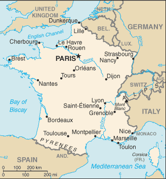
Calais, Dunkerque, Le Havre, Marseille, Nantes, Paris, Rouen
Comments
Add a new comment: |
Advertisement
Members area
France (Paris):
 
GPS points from France (Paris)
|
||||||||

 France today is one of the most modern countries in the world and is a leader among European nations. It plays an influential global role as a permanent member of the United Nations Security Council, NATO, the G-8, the G-20, the EU and other multilateral organizations. France rejoined NATO's integrated military command structure in 2009, reversing de Gaulle's 1966 decision to take French forces out of NATO. Since 1958, it has constructed a hybrid presidential-parliamentary governing system resistant to the instabilities experienced in earlier more purely parliamentary administrations. In recent decades, its reconciliation and cooperation with Germany have proved central to the economic integration of Europe, including the introduction of a common exchange currency, the euro, in January 1999. In the early 21st century, five French overseas entities - French Guiana, Guadeloupe, Martinique, Mayotte, and Reunion - became French regions and were made part of France proper.