|
|
|
Advertisements:
GeographyLocation
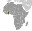
Western Africa, bordering the Gulf of Guinea, between Cote d'Ivoire and Togo Geographic coordinates
8 00 N, 2 00 W
Map references
Africa
Area World Ranking: 82
Total 238,533 sq km
Land 227,533 sq km Water 11,000 sq km Area - comparative
Slightly smaller than Oregon
Land boundaries
Total 2,094 km
Border countries Burkina Faso 549 km, Cote d'Ivoire 668 km, Togo 877 km Coastline
539 km
Maritime claims
Territorial sea 12 nm
Contiguous zone 24 nm Exclusive economic zone 200 nm Continental shelf 200 nm Climate
Tropical; warm and comparatively dry along southeast coast; hot and humid in southwest; hot and dry in north Terrain
Mostly low plains with dissected plateau in south-central area Elevation extremes
Lowest point Atlantic Ocean 0 m
Highest point Mount Afadjato 885 m Natural resources
Gold, timber, industrial diamonds, bauxite, manganese, fish, rubber, hydropower, petroleum, silver, salt, limestone Land use
Arable land 17.54%
Permanent crops 9.22% Other 73.24% (2005) Irrigated land
340 sq km (2003)
Total renewable water resources
53.2 cu km (2001)
Freshwater withdrawal (domestic/industrial/agricultural)
Total 0.98 cu km/yr (24%/10%/66%)
Per capita 44 cu m/yr (2000) Natural hazards
Dry, dusty, northeastern harmattan winds from January to March; droughts Environment - current issues
Recurrent drought in north severely affects agricultural activities; deforestation; overgrazing; soil erosion; poaching and habitat destruction threatens wildlife populations; water pollution; inadequate supplies of potable water Environment - international agreements
Party to
Biodiversity, Climate Change, Climate Change-Kyoto Protocol, Desertification, Endangered Species, Environmental Modification, Hazardous Wastes, Law of the Sea, Ozone Layer Protection, Ship Pollution, Tropical Timber 83, Tropical Timber 94, Wetlands Signed, but not ratified Marine Life ConservationGeography - note
Lake Volta is the world's largest artificial lake by surface area (8,482 sq km; 3,275 sq mi)
Comments
Add a new comment: |
Advertisement
Members area
Ghana (Accra):
 
GPS points from Ghana (Accra)
|
||||||||

 Formed from the merger of the British colony of the Gold Coast and the Togoland trust territory, Ghana in 1957 became the first sub-Saharan country in colonial Africa to gain its independence. Ghana endured a long series of coups before Lt. Jerry RAWLINGS took power in 1981 and banned political parties. After approving a new constitution and restoring multiparty politics in 1992, RAWLINGS won presidential elections in 1992 and 1996 but was constitutionally prevented from running for a third term in 2000. John KUFUOR succeeded him and was reelected in 2004. John Atta MILLS took over as head of state in early 2009.